PYRTPlan Your Road Trips
Create TripCommunityMerchandise
PYRTPlan Your Road Trips
Create TripCommunityMerchandise
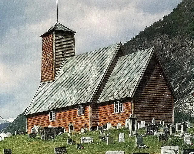
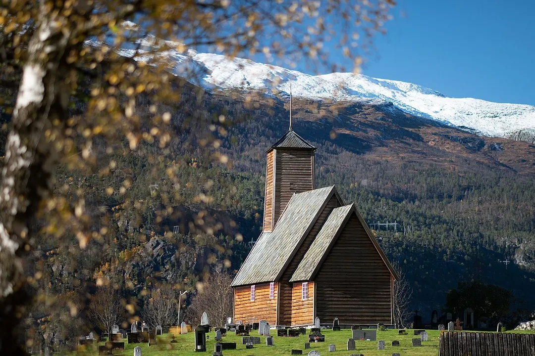
Gaupne gamle kirke
Norsk nynorsk:  Gaupne gamle kyrkje.


This image was uploaded as part of Wiki Loves Monuments 2022.

Afrikaans ∙ Alemannisch ∙ አማርኛ ∙ aragonés ∙ العربية ∙ جازايرية ∙ asturianu ∙ azərbaycanca ∙ Bikol Central ∙ беларуская ∙ беларуская (тарашкевіца) ∙ български ∙ বাংলা ∙ brezhoneg ∙ bosanski ∙ català ∙ čeština ∙ Cymraeg ∙ dansk ∙ Deutsch ∙ Zazaki ∙ Ελληνικά ∙ English ∙ Esperanto ∙ español ∙ eesti ∙ euskara ∙ فارسی ∙ suomi ∙ français ∙ Frysk ∙ Gaeilge ∙ galego ∙ עברית ∙ हिन्दी ∙ hrvatski ∙ magyar ∙ հայերեն ∙ Bahasa Indonesia ∙ Ido ∙ italiano ∙ 日本語 ∙ ქართული ∙ қазақша ∙ 한국어 ∙ кыргызча ∙ Lëtzebuergesch ∙ lietuvių ∙ latviešu ∙ Malagasy ∙ македонски ∙ മലയാളം ∙ Bahasa Melayu ∙ Malti ∙ မြန်မာဘာသာ ∙ norsk bokmål ∙ नेपाली ∙ Nederlands ∙ norsk nynorsk ∙ norsk ∙ polski ∙ português ∙ português do Brasil ∙ română ∙ русский ∙ sicilianu ∙ davvisámegiella ∙ slovenčina ∙ slovenščina ∙ shqip ∙ српски / srpski ∙ svenska ∙ тоҷикӣ ∙ ไทย ∙ Tagalog ∙ Türkçe ∙ українська ∙ اردو ∙ oʻzbekcha / ўзбекча ∙ Yorùbá ∙ 中文 ∙ 中文(中国大陆) ∙ 中文(简体) ∙ 中文(繁體) ∙ 中文(香港) ∙ 中文(臺灣) ∙ +/−


This is a photo of a monument in Norway, number: 84236 in the Norwegian Directorate for Cultural Heritage database.
GAUPNE Norway 2025 Vadim Chuprina
Photo by kirkenorge.no
Destinations
Home›Destinations›Gaupne
EuropeNorwayVestland

Gaupne

Vestland, Norway · Europe

About Gaupne

Gaupne is worth a stop: 20 minutes from Luster, 26km from Tindevegen.

Gaupne is in Vestland, Norway, with about 1,300 people. You drive on the right here. The nearest town is Luster, about 10 km away.

Gaupne is the administrative center of Luster Municipality in Vestland county, Norway. The village is located along the Gaupnefjorden, an arm of the Lustrafjorden, about 10 kilometres (6.2 mi) north of the village of Hafslo. The village of Veitastrond is located across the mountains 20 kilometres (12 mi) to the

Read more northwest. The Sognefjellsvegen road passes through here on its way to the village of Skjolden and beyond. The 1.5-square-kilometre (370-acre) village has a population (2025) of 1,294 and a population density of 863 inhabitants per square kilometre (2,240/sq mi). Gaupne sits at the southern end of the Jostedalen valley, with the river Jostedøla's mouth located in Gaupne. It sits southwest of the Jostedalsbreen glacier, between Jostedalsbreen National Park and Breheimen National Park. The village is about 40 kilometres (25 mi) south of the famous Nigardsbreen glacier, and the Breheimsenteret museum is located about 25 kilometres (16 mi) to the north of Gaupne in the village of Jostedal. There are two churches in Gaupne: the historic Old Gaupne Church and the newer Gaupne Church.

Read more on Wikipedia

Where to Stay in Gaupne

Compare prices across Booking.com, Airbnb, Expedia, and more. Select your dates to see availability.

Filter presets

Pick your must-haves once: provider links open pre-filtered. Each filter lists which sites it applies to.

Booking.comExpediaTripAdvisorHotels.comAgodaAirbnb

Compare before you book!

Prices can vary significantly between platforms. We recommend checking at least 2-3 sites to find the best deal for your stay in Gaupne.

Explore the Area

Discover famous landmarks, scenic roads, and more near Gaupne.

Loading map...
Open in Google Maps

Frequently Asked Questions

What is there to see near Gaupne?

Within an hour or so of Gaupne: Urnes Stave Church (12 km), Tindevegen (26 km), Turtagrø (29 km), Bøyabreen (31 km).

Are there any good drives near Gaupne?

The nearest famous roads are Tindevegen, Sognefjellet National Tourist Route and Vindhellavegen.

Where is Gaupne?

Gaupne is in Vestland, Norway, about 10 km from Luster.

Road trip

Drive to Gaupne

Add it as a stop and the planner works out the driving, the nights and what's worth seeing on the way.

Start planning

What's nearby?

Swipe through places to go

Places within a drive of Gaupne. Keep the ones you like and add them to your trip.

Explore now

Quick Information

Population
1,257
Continent
Europe
Country
Norway
Region
Vestland
Timezone
Europe/Oslo
Coordinates
61.4047, 7.2946

Emergency & Services

Essential numbers in Norway

Police
112
Ambulance
113
Fire
110
Driving side
right

Many toll roads use automatic plate recognition (AutoPASS). Headlights required at all times.

Full driving guide for Norway

Tags

EuropeNorwayVestlandTown

Worth the detour from Gaupne

8 notable places within an hour's drive.

cathedral

Urnes Stave Church

The oldest surviving stave church in Norway, a UNESCO-listed 12th-century wooden masterpiece overlooking the Lustrafjord.

12 km · about 20 min drive

famous road

Tindevegen

A private toll road between Årdal and Turtagrø crossing bare rock country on the edge of Jotunheimen, with the Hurrungane peaks alongside.

26 km · about 30 min drive

scenic viewpoint

Turtagrø

The historic climbers' hotel at the foot of the Hurrungane, where Norwegian alpinism began, on the Sognefjellet road.

29 km · about 35 min drive

natural wonder

Bøyabreen

An arm of the Jostedalsbreen icefall hanging above a meltwater lake, visible from a car park directly off the road near Fjærland.

31 km · about 35 min drive

natural wonder

Nigardsbreen

A photogenic blue glacier tongue of Jostedalsbreen reached across a glacier lake by small boat.

33 km · about 40 min drive

famous road

Sognefjellet National Tourist Route

Northern Europe's highest mountain pass road at 1,434 meters, crossing between the Jotunheimen peaks in Norway.

34 km · about 40 min drive

natural wonder

Briksdalsbreen

An arm of the Jostedal glacier spilling toward a turquoise meltwater lake at the end of a green valley.

36 km · about 40 min drive

natural wonder

Kjenndalsbreen

A glacier arm at the head of Lovatnet, reached by a narrow toll road through a valley scarred by two catastrophic rockslides.

38 km · about 45 min drive

Driving roads near Gaupne

  • 26 kmTindevegenA private toll road between Årdal and Turtagrø crossing bare rock country on the edge of Jotunheimen, with the Hurrungane peaks alongside.
  • 29 kmTurtagrøThe historic climbers' hotel at the foot of the Hurrungane, where Norwegian alpinism began, on the Sognefjellet road.
  • 34 kmSognefjellet National Tourist RouteNorthern Europe's highest mountain pass road at 1,434 meters, crossing between the Jotunheimen peaks in Norway.
  • 41 kmLærdal TunnelWorld's longest road tunnel at 24.5 km with unique lighting design
  • 42 kmUtsikten Viewpoint (Gaularfjellet)An angular concrete viewing platform on the Gaularfjellet tourist route, cantilevered over the hairpins below.
  • 42 kmVedahaugane (Aurlandsfjellet)A rest stop on the Aurlandsfjellet snow road where the tarmac runs between walls of snow well into summer.

When to drive here

May to September

Far northern latitude: short daylight hours outside summer make long drives harder.

Nearby Destinations

Other places to explore near Gaupne.

Luster

🇳🇴 Norway

10 km awayPop. 5,302

Sogndal

🇳🇴 Norway

22 km awayPop. 3,995

Sogndalsfjøra

🇳🇴 Norway

22 km awayPop. 3,995

Årdalstangen

🇳🇴 Norway

29 km awayPop. 1,375

Vikøyri

🇳🇴 Norway

52 km awayPop. 2,899

Vik

🇳🇴 Norway

54 km awayPop. 2,899

Aurlandsvangen

🇳🇴 Norway

56 km away

Stryn

🇳🇴 Norway

63 km awayPop. 7,207

Plan a trip around Gaupne

Norway road trip planner

Your trip starts here

Plan a road trip from Gaupne.

Pick the days, drop in the stops, and share it with whoever's coming.

Start planning
PYRT

The ultimate road trip planning platform. Discover 150,000+ destinations worldwide, plan scenic routes, and create unforgettable adventures.

Inspiration

  • Discover Trips
  • Travel Guides
  • Community

The Product

  • Calendar Planner
  • Integrations
  • How It Works
  • Collaboration Mode
  • Get the App
  • Merchandise: PYRT Supply Co.
  • Become a Creator
  • Trip Marketplace

Plan Your Trip

  • Road Trip Planner
  • Famous Routes
  • Drive Times & Distances
  • Planners by Country
  • Best Road Trip Planner App
  • Discover Road Trips
  • Events
  • Travel Guides
  • How It Works
  • My Trips
  • Community Groups

Company

  • Terms of Service
  • Privacy Policy
  • About PYRT
  • Support
  • Contact Us
  • Sign In
  • Create Account

© 2026 Plan Your Road Trips. All rights reserved.

•[email protected]
Data sources:GeoNames (CC BY 4.0)•Wikimedia Commons (CC BY-SA)•Mapbox•Photography: George Lawrence