PYRTPlan Your Road Trips
Create TripCommunityMerchandise
PYRTPlan Your Road Trips
Create TripCommunityMerchandise
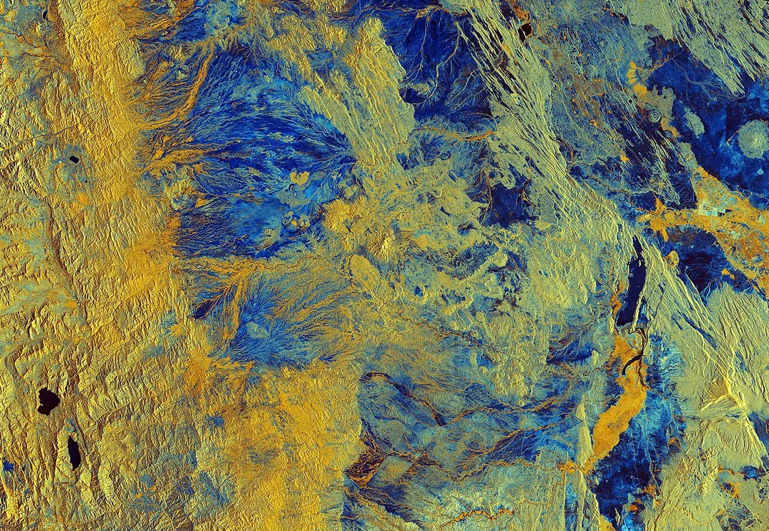
The Copernicus Sentinel-1B satellite takes us over Semera in northeast Ethiopia. Semera is a new town with a population of just over 2600 and serves as the capital of the Afar region. The region spans an estimated 270 000 sq km, from close to the border with Eritrea towards the capital of Addis Ababa.
We can see the regional capital in the top right of this false-colour image, with the larger urban centre of Dubti just south of the town. Both are found in the Great Rift Valley, which lies between the Ethiopian Plateau and the Somalia Plateau.
The landscape of the Afar region is characterised by desert shrubland and volcanoes, particularly in the north. In this image we can see differences in altitude represented in the variations in colour. The left part of the image is dominated by yellow, signifying changes in vegetation found at higher altitudes. Two lakes, Hayk Lake and Hardibo Lake, are shown in the bottom left.
South of Dubti we can see the Awash River, which flows into the northern salt lakes rather than into the sea. Salt trade is typical of the area, whilst cotton is grown in the Awash River valley. Maize, beans, papaya and bananas are also cultivated in the Afar region. It is thought that 90% of the region’s population lead a pastoral life, rearing animals such as camels, sheep and donkeys.
Dallol, to the north of Semera in Ethiopia’s Danakil Depression, is frequently cited as one of the hottest inhabited places on Earth. Lying 125 m below sea level, with temperatures in the spectacular hydrothermal fields averaging 34.4 °C year-round, and the area receiving just 100–200 mm rainfall a year, conditions are thought to be amongst the most inhospitable in the world.
Sentinel-1B was launched in April 2016, carrying an advanced radar instrument to provide an all-weather, day-and-night supply of imagery of Earth’s surface. Along with Sentinel-1A, which was launched in April 2014, the mission benefits numerous services, including monitoring land-surface for motion risks and mapping to support crisis situations.

This image, which was captured on 5 April 2018, is also featured on the Earth from Space video programme.
The Copernicus Sentinel-1B satellite takes us over Semera in northeast Ethiopia. Semera is a new town with a population of just over 2600 and serves as the capital of the Afar region. The region spans an estimated 270 000 sq km, from close to the border with Eritrea towards the capital of Addis Ababa.We can see the regional capital in the top right of this false-colour image, with the larger urban centre of Dubti just south of the town. Both are found in the Great Rift Valley, which lies between the Ethiopian Plateau and the Somalia Plateau.The landscape of the Afar region is characterised by desert shrubland and volcanoes, particularly in the north. In this image we can see differences in altitude represented in the variations in colour. The left part of the image is dominated by yellow, signifying changes in vegetation found at higher altitudes. Two lakes, Hayk Lake and Hardibo Lake, are shown in the bottom left.South of Dubti we can see the Awash River, which flows into the northern salt lakes rather than into the sea. Salt trade is typical of the area, whilst cotton is grown in the Awash River valley. Maize, beans, papaya and bananas are also cultivated in the Afar region. It is thought that 90% of the region’s population lead a pastoral life, rearing animals such as camels, sheep and donkeys.Dallol, to the north of Semera in Ethiopia’s Danakil Depression, is frequently cited as one of the hottest inhabited places on Earth. Lying 125 m below sea level, with temperatures in the spectacular hydrothermal fields averaging 34.4 °C year-round, and the area receiving just 100–200 mm rainfall a year, conditions are thought to be amongst the most inhospitable in the world.Sentinel-1B was launched in April 2016, carrying an advanced radar instrument to provide an all-weather, day-and-night supply of imagery of Earth’s surface. Along with Sentinel-1A, which was launched in April 2014, the mission benefits numerous services, including monitoring land-surface for motion risks and mapping to support crisis situations.This image, which was captured on 5 April 2018, is also featured on the Earth from Space video programme.
07/12/2022. Semera, Ethiopia. Foreign Secretary James Cleverly visits Dubti Hospital in Semera. Picture by Simon Dawson / No 10 Downing Street
Photo by European Space Agency
Destinations
Home›Destinations›Dubti
AfricaEthiopiaĀfar

Dubti

Āfar, Ethiopia · Africa

About Dubti

Dubti sits on the route: 20 minutes from Samara.

Dubti is in Āfar, Ethiopia, with about 36,000 people. The nearest town is Samara, about 11 km away.

Dubti is a town Administration in north-east Ethiopia. Located in Awsi Rasu, Afar Region, this town has a latitude and longitude of 11°44′N 41°05′E with an elevation of 378 meters above sea level. A UN-EUE mission, accompanied by two non-government organizations, surveying conditions in the Afar Region and visited

Read more Dubti 13 December 1995, at which time the town had one of two hospitals in Afar. While it offered the most advanced treatment in the Region, services available stopped short of surgery, providing only minor surgery under local anesthesia. Based on figures from the Central Statistical Agency published in 2005, Dubti has an estimated total population of 15,445, of whom 8,501 are men and 6,944 are women. It is the largest of five towns in Dubti woreda.

Read more on Wikipedia

Where to Stay in Dubti

Compare prices across Booking.com, Airbnb, Expedia, and more. Select your dates to see availability.

Filter presets

Pick your must-haves once: provider links open pre-filtered. Each filter lists which sites it applies to.

Booking.comExpediaTripAdvisorHotels.comAgodaAirbnb

Compare before you book!

Prices can vary significantly between platforms. We recommend checking at least 2-3 sites to find the best deal for your stay in Dubti.

Explore the Area

Discover famous landmarks, scenic roads, and more near Dubti.

Loading map...
Open in Google Maps

Frequently Asked Questions

Where is Dubti?

Dubti is in Āfar, Ethiopia, about 11 km from Samara.

Road trip

Drive to Dubti

Add it as a stop and the planner works out the driving, the nights and what's worth seeing on the way.

Start planning

What's nearby?

Swipe through places to go

Places within a drive of Dubti. Keep the ones you like and add them to your trip.

Explore now

Quick Information

Population
36,100
Continent
Africa
Country
Ethiopia
Region
Āfar
Timezone
Africa/Addis_Ababa
Coordinates
11.7329, 41.0820

Tags

AfricaEthiopiaĀfarTown

When to drive here

Year-round

Tropical latitude: plan around the wet season rather than temperature.

Nearby Destinations

Other places to explore near Dubti.

Samara

🇪🇹 Ethiopia

11 km awayPop. 50,000

Asaita

🇪🇹 Ethiopia

43 km awayPop. 39,400

Mīlē

🇪🇹 Ethiopia

49 km awayPop. 21,700

Batī

🇪🇹 Ethiopia

131 km awayPop. 37,600

Mersa

🇪🇹 Ethiopia

156 km awayPop. 36,300

Hāyk’

🇪🇹 Ethiopia

160 km awayPop. 28,500

Harbu

🇪🇹 Ethiopia

168 km awayPop. 24,500

Āt’aye

🇪🇹 Ethiopia

198 km awayPop. 26,300

Your trip starts here

Plan a road trip from Dubti.

Pick the days, drop in the stops, and share it with whoever's coming.

Start planning
PYRT

The ultimate road trip planning platform. Discover 150,000+ destinations worldwide, plan scenic routes, and create unforgettable adventures.

Inspiration

  • Discover Trips
  • Travel Guides
  • Community

The Product

  • Calendar Planner
  • Integrations
  • How It Works
  • Collaboration Mode
  • Get the App
  • Merchandise: PYRT Supply Co.
  • Become a Creator
  • Trip Marketplace

Plan Your Trip

  • Road Trip Planner
  • Famous Routes
  • Drive Times & Distances
  • Planners by Country
  • Best Road Trip Planner App
  • Discover Road Trips
  • Events
  • Travel Guides
  • How It Works
  • My Trips
  • Community Groups

Company

  • Terms of Service
  • Privacy Policy
  • About PYRT
  • Support
  • Contact Us
  • Sign In
  • Create Account

© 2026 Plan Your Road Trips. All rights reserved.

•[email protected]
Data sources:GeoNames (CC BY 4.0)•Wikimedia Commons (CC BY-SA)•Mapbox•Photography: George Lawrence