
landmark
Saltburn-by-the-Sea
A Victorian seaside resort with a surviving pier and the world's oldest working water-balance cliff lift, opened in 1884.
5 km · about 10 min drive
England, United Kingdom · Europe
Boosbeck works well as a base: 5 minutes from Brotton, 20km from North York Moors National Park.
Boosbeck is in England, United Kingdom, with about 1,200 people. You drive on the left here. The nearest town is Brotton, about 4 km away.
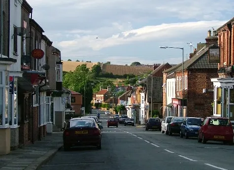
Boosbeck is a village in the borough of Redcar and Cleveland and the ceremonial county of North Yorkshire, England.
The name is Viking in origin and means "the stream near a cow shed".
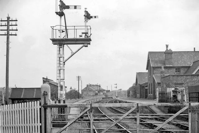
Between 1878 and 1960, the village had a station on the North Eastern Railway line between Brotton and Guisborough. It was closed toRead more
passengers in 1960 but continued to be used for freight until 1964.
Lockwood Primary School is located on the southern edge of the village. It was opened in 1984, replacing an earlier 1881 school on the same road. The former school has since been home to Castle Court Nursing Home and currently Morgan House, a Specialist Veterans Hub.
Boosbeck is home to one public house, the Top House formerly known as the Commercial Hotel, and Boosbeck Hotel. A second public house, the Station Hotel closed in 2023.
Compare prices across Booking.com, Airbnb, Expedia, and more. Select your dates to see availability.
Pick your must-haves once: provider links open pre-filtered. Each filter lists which sites it applies to.
Compare before you book!
Prices can vary significantly between platforms. We recommend checking at least 2-3 sites to find the best deal for your stay in Boosbeck.
Discover famous landmarks, scenic roads, and more near Boosbeck.
Within an hour or so of Boosbeck: Saltburn-by-the-Sea (5 km), Roseberry Topping (9 km), Staithes (12 km), Runswick Bay (15 km).
The nearest famous roads are Rosedale Chimney Bank, B6270 Swaledale and Buttertubs Pass.
Boosbeck is in England, United Kingdom, about 4 km from Brotton.
Road trip
Add it as a stop and the planner works out the driving, the nights and what's worth seeing on the way.
Start planningSwipe through places to go
Places within a drive of Boosbeck. Keep the ones you like and add them to your trip.
Essential numbers in United Kingdom
112 also works. NHS non-emergency medical advice: 111. National Highways breakdown assistance on motorways: 0300 123 5000.
Full driving guide for United Kingdom8 notable places within an hour's drive.
landmark
A Victorian seaside resort with a surviving pier and the world's oldest working water-balance cliff lift, opened in 1884.
5 km · about 10 min drive
scenic viewpoint
A distinctive half-cone hill on the edge of the North York Moors, its shape the result of a 1912 landslip caused by mining.
9 km · about 15 min drive
photogenic
Former fishing village of red-roofed cottages stacked into a cleft in the North Yorkshire cliffs, where Captain Cook worked as a grocer's boy. Park at the top and walk down: the harbour view from Cowbar Nab is the classic shot.
12 km · about 25 min drive
beach
A sheltered cove of red-roofed cottages tumbling down the cliff to a sandy beach, popular for fossil hunting.
15 km · about 30 min drive
national park
Vast expanse of heather moorland turning purple in August, with deep valleys, a dramatic coastline and the historic North Yorkshire Moors Railway.
20 km · about 25 min drive
famous road
One of England's steepest roads, hitting 1-in-3 (33%) as it climbs from Rosedale Abbey onto the North York Moors past old ironstone kilns. A rite of passage for drivers and cyclists; caravans are banned.
23 km · about 25 min drive
film location
This preserved North Yorkshire Moors Railway station was Hogsmeade Station in Harry Potter and the Philosopher's Stone, where students arrive by steam train.
23 km · about 25 min drive
waterfall
The tallest waterfall in the North York Moors at around 21 m, in a wooded ravine below Goathland.
23 km · about 25 min drive
5 named roads, passes and coastal drives within 100km.
April to October
Other places to explore near Boosbeck.
Your trip starts here
Pick the days, drop in the stops, and share it with whoever's coming.