
landmark
Stanley Park Totem Poles
Collection of First Nations totem poles in Vancouver's Stanley Park, one of the most visited attractions in British Columbia.
31 km · about 35 min drive
British Columbia, Canada · North America
Tsawwassen sits on the route: 5 minutes from Point Roberts, 54km from San Juan Islands.
Tsawwassen is a town located in British Columbia, Canada. With a population of 21,588, it is an important destination in North America.
On a road trip, Tsawwassen sits in Canada, where you drive on the right. It's in the America/Vancouver time zone. Below you'll find where to stay, things to do nearby, and everything you need to add Tsawwassen to your route.
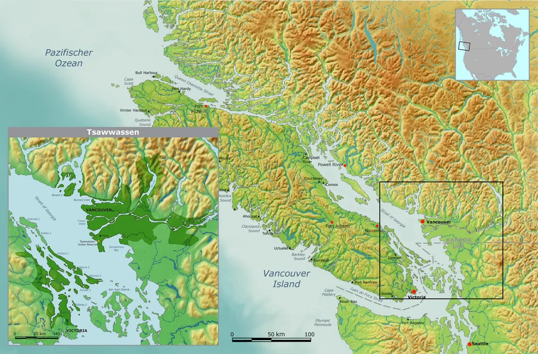
Tsawwassen (English: ; Halkomelem: sc̓əwaθən) is a suburban, mostly residential community on a peninsula in the southwestern corner of the City of Delta in British Columbia, Canada. It provides the only road access to the American territory on the southern tip of the peninsula of the same name, the community of PointRead more
Roberts, Washington, via 56th Street. It is also the location of Tsawwassen Ferry Terminal, part of the BC Ferries, built in 1959 to provide foot-passenger and motor vehicle access from the Lower Mainland to the southern part of Vancouver Island and the southern Gulf Islands. Because Tsawwassen touches a shallow bank (Roberts Bank), the ferry terminal is built at the southwestern end of a 3 km (1.9 mi) causeway (part of Highway 17) that juts into the Strait of Georgia. Boundary Bay Airport, a major training hub for local and international pilots which also provides local airplane and helicopter service, is ten minutes away. The Roberts Bank Superport is also nearby.
To the northwest of the community are the lands of Tsawwassen First Nation ("TFN"), a people of Coast Salish ancestry who have used this land since at least 200 B.C. Having been stripped of their lands, rights and resources by European colonizers throughout the 19th century, and in accordance with a 2009 treaty with British Columbia, their territory now consists of approximately 724 ha (1,790 acres) of treaty settlement land, bounded by the Strait of Georgia on the west, the 2600 block to the north, the 4800 block to the east, and the 1200 block to the south. While also part of TFN lands, the 92-lot residential subdivision of Stahaken was leased for use by the (then) Tsawwassen Indian Reserve to Staheken Developments Ltd. in 1989 for a 99-year term. It was then developed in a partnership between Stahaken Development Ltd. and the Municipality of Delta. As such it is commonly thought of and serviced in the same manner as other subdivisions in the community of Tsawwassen. Stahaken residents are represented by the Stahaken Homeowners Association.
Compare prices across Booking.com, Airbnb, Expedia, and more. Select your dates to see availability.
Pick your must-haves once: provider links open pre-filtered. Each filter lists which sites it applies to.
Compare before you book!
Prices can vary significantly between platforms. We recommend checking at least 2-3 sites to find the best deal for your stay in Tsawwassen.
Discover famous landmarks, scenic roads, and more near Tsawwassen.
Tsawwassen offers many attractions including tourist sites, museums, parks, and local restaurants. Explore famous landmarks, scenic roads, and natural wonders on our interactive map and plan your visit.
Plan your road trip to Tsawwassen with Plan Your Road Trips! Add Tsawwassen as a destination, and we'll help you find the best route and discover more amazing places along the way.
Tsawwassen is located in British Columbia, Canada, North America. The coordinates are 49.0167 latitude, -123.0833 longitude.
Tsawwassen has a population of approximately 21,588 people, making it a town in Canada.
Add to your itinerary
Start planning your road trip with Tsawwassen as a destination. Create a custom route and discover more amazing places along the way.
Start Road TripDiscover destinations like Tinder
Swipe through stunning destinations near Tsawwassen. Save your favourites and add them to your trip.
Essential numbers in Canada
CAA roadside assistance: 1-800-222-4357. Winter tyres mandatory in Quebec December–March.
Full driving guide for Canada6 notable places within an hour's drive.
landmark
Collection of First Nations totem poles in Vancouver's Stanley Park, one of the most visited attractions in British Columbia.
31 km · about 35 min drive
landmark
Canada's largest aquarium in Stanley Park dedicated to the conservation of aquatic life in the Pacific Northwest.
32 km · about 35 min drive
bridge
Vancouver's iconic 1938 suspension bridge spanning the First Narrows from Stanley Park to the North Shore, gateway to the Sea-to-Sky Highway with mountain and harbour views from its green towers.
33 km · about 40 min drive
bridge
A 137 m footbridge swaying 70 m above the Capilano River in North Vancouver, with treetop walkways and a granite cliffwalk: one of BC's most visited attractions since 1889.
36 km · about 40 min drive
natural wonder
A scenic Pacific Northwest archipelago accessible by ferry, renowned for orca whale watching, kayaking, and peaceful island life.
54 km · about 60 min drive
coastal drive
Washington's first scenic byway clings to sandstone cliffs between Bellingham and the Skagit flats, with oyster bars and Samish Bay sunsets over the San Juan Islands.
59 km · about 70 min drive
Other places to explore near Tsawwassen.
Create your perfect itinerary with our calendar-based planner. Add stops, discover attractions along the way, and share your trip with friends.
Start Planning