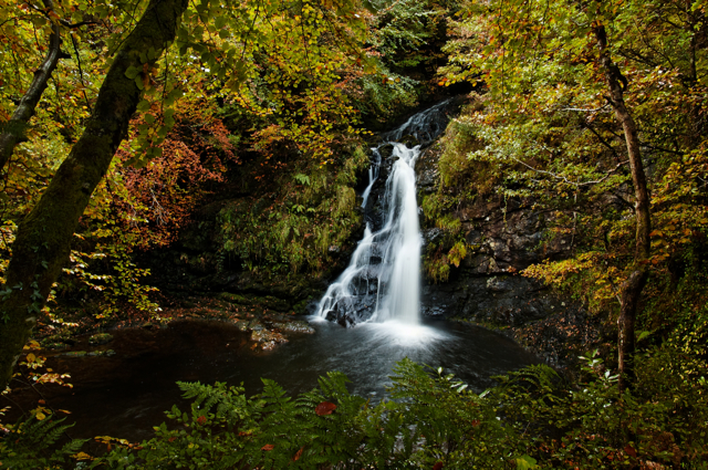


waterfall
Aasleagh Falls
A broad low waterfall on the Erriff River near the head of Killary Harbour, a short walk from a roadside car park.
20 km · about 25 min drive
Connacht, Ireland · Europe
Toormakeady works well as a base: 15 minutes from Ballinrobe, 27km from Killary Harbour.
Toormakeady is a town located in Connacht, Ireland. With a population of 1,007, it is an important destination in Europe.
On a road trip, Toormakeady sits in Ireland, where you drive on the left. It's in the Europe/Dublin time zone. Below you'll find where to stay, things to do nearby, and everything you need to add Toormakeady to your route.
Toormakeady or Tourmakeady (Irish: Tuar Mhic Éadaigh, the official name) is a Gaeltacht in south County Mayo in the west of Ireland. It is located between the shores of Lough Mask and the Partry Mountains, and covers 172.26 square kilometres (66.51 sq mi). As at the time of the 2011 census, Toormakeady had a totalRead more
population of 1,007, having dropped from 1,150 in 1991. Toormakeady is also the name of the principal village in the area.
Those parts of Ballinchalla Electoral District in Toormakeady and the whole of the Owenbrin Electoral District in Toormakeady together comprise nearly half of the land area of Toormakeady and were previously parts of County Galway. In 1898 they were transferred to County Mayo.
From the time of the Great Famine of the mid-1840s onwards, the Toormakeady area has experienced a high level of emigration. Many descendants of emigrants return every year to find their roots. The genealogical records for this area have been computerised at the South Mayo Family Research Centre in nearby Ballinrobe to make the task of tracing roots easier.
On 3 May 1921, during the Irish War of Independence the Irish Republican Army south Mayo flying column of around 30 men together with a small number of men from east Mayo mounted an ambush at Toormakeady. The events of this day have been written about in Donal Buckley's book The Battle of Tourmakeady.
The English actor Robert Shaw, best known for his work in From Russia with Love, Jaws and The Sting, lived in Drimbawn House, Toormakeady until his death in 1978. Television producer Máire Ní Thuathail was born in Toormakeady in 1957.
The local sport clubs in Toormakeady include, CLG Thuar Mhic Éadaigh and Partry Athletic Football Club.
Compare prices across Booking.com, Airbnb, Expedia, and more. Select your dates to see availability.
Pick your must-haves once: provider links open pre-filtered. Each filter lists which sites it applies to.
Compare before you book!
Prices can vary significantly between platforms. We recommend checking at least 2-3 sites to find the best deal for your stay in Toormakeady.
Discover famous landmarks, scenic roads, and more near Toormakeady.
Toormakeady offers many attractions including tourist sites, museums, parks, and local restaurants. Explore famous landmarks, scenic roads, and natural wonders on our interactive map and plan your visit.
Plan your road trip to Toormakeady with Plan Your Road Trips! Add Toormakeady as a destination, and we'll help you find the best route and discover more amazing places along the way.
Toormakeady is located in Connacht, Ireland, Europe. The coordinates are 53.6500 latitude, -9.3667 longitude.
Toormakeady has a population of approximately 1,007 people, making it a town in Ireland.
Add to your itinerary
Start planning your road trip with Toormakeady as a destination. Create a custom route and discover more amazing places along the way.
Start Road TripDiscover destinations like Tinder
Swipe through stunning destinations near Toormakeady. Save your favourites and add them to your trip.
8 notable places within an hour's drive.
waterfall
A broad low waterfall on the Erriff River near the head of Killary Harbour, a short walk from a roadside car park.
20 km · about 25 min drive
scenic viewpoint
Ireland's holiest mountain at 764 metres, where St Patrick is said to have fasted for 40 days, with sweeping views over Clew Bay.
23 km · about 25 min drive
natural wonder
Ireland's only true fjord, a 16km glacial inlet flanked by mountains on the Galway-Mayo border.
27 km · about 30 min drive
scenic viewpoint
Brooding mountain pass on the R335 between Louisburgh and Delphi where dark Doo Lough fills the valley floor between Mweelrea and the Sheeffry Hills. A stone cross remembers the 1849 Famine death march along this road.
27 km · about 30 min drive
scenic viewpoint
A glacial valley on the R344 in Connemara with a long lake wedged between the Twelve Bens and the Maumturks.
29 km · about 35 min drive
scenic viewpoint
The Connemara lake with the much-photographed pine-covered islet, seen from a lay-by on the N59 near Recess.
31 km · about 35 min drive
beach
A steep-sided sandy cove west of Louisburgh reached by a long flight of steps, facing straight into the Atlantic.
34 km · about 40 min drive
landmark
Stunning Gothic castle on the shore of Kylemore Lough in Connemara, now home to Benedictine nuns with a Victorian walled garden.
36 km · about 40 min drive
April to October
Other places to explore near Toormakeady.
Create your perfect itinerary with our calendar-based planner. Add stops, discover attractions along the way, and share your trip with friends.
Start Planning