PYRTPlan Your Road Trips
Create TripMy TripsCommunityMerchandise
PYRTPlan Your Road Trips
Create TripMy TripsCommunityMerchandise
T
Destinations
Home›Destinations›Tepotzotlán
North AmericaMexicoMéxico

Tepotzotlán

México, Mexico · North America

About Tepotzotlán

Tepotzotlán is worth a stop: 5 minutes from Barrio Tlatenco, 34km from Chapultepec Castle.

Tepotzotlán is a town located in México, Mexico. With a population of 38,119, it is an important destination in North America.

On a road trip, Tepotzotlán sits in Mexico, where you drive on the right. It's in the America/Mexico City time zone. Below you'll find where to stay, things to do nearby, and everything you need to add Tepotzotlán to your route.

About Tepotzotlán

Tepotzotlán (Spanish: [tepotsoˈtlan] ) is a city and a municipality in the Mexican state of Mexico. It is located 40 km (25 mi) northwest of Mexico City about a 45-minute drive along the Mexico City–Querétaro road at marker number 41. In Aztec times, the area was the center of a dominion that negotiated to keep most

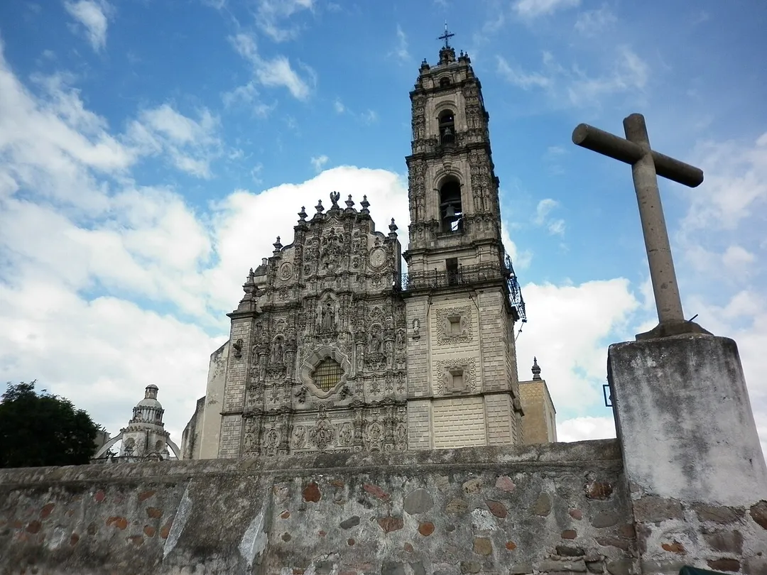
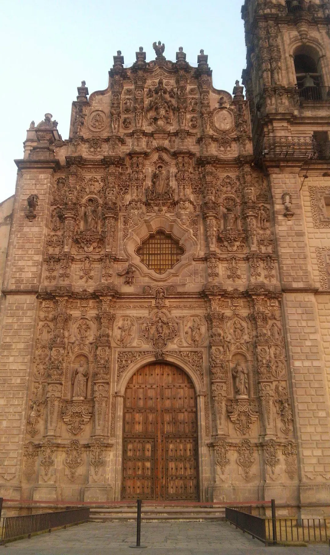
Read more of its independence in return with being allied with the Aztec Triple Alliance. Later, it would also be part of a "Republic of the indigenous," allowing for some autonomy under Spanish rule as well. The town became a major educational center during the colonial period when the Jesuits established the College of San Francisco Javier. The college complex that grew from its beginnings in 1580 would remain an educational center until 1914. Today this complex houses the Museo del Virreinato (Museum of the Vice Regal or Colonial Period), with one of the largest collections of art and other objects from this time period. The name Tepotzotlán is of Nahuatl origin and means "among humpbacks," referring to the shape of the hills that surround this area. The oldest surviving Aztec glyph for this area is found in the Codex Osuna, which features a humpbacked person sitting on top of a hill. This is now the symbol of the municipality. Another version of the glyph shows a humpbacked person defending a "teocalli" or sacred precinct. The municipality also has a lesser-known European-style coat-of-arms. This contains the officially adopted version of the glyph in the upper part, a representation of the Arcos del Sitio, the facade of the Church of San Francisco Javier and chimneys and a tractor representing both the agriculture and industry found here. Underneath these are written the words "Libertad, Cultura y Trabajo" (Liberty, Culture and Work).

Read more on Wikipedia

Where to Stay in Tepotzotlán

Compare prices across Booking.com, Airbnb, Expedia, and more. Select your dates to see availability.

Filter presets

Pick your must-haves once: provider links open pre-filtered. Each filter lists which sites it applies to.

Booking.comExpediaTripAdvisorHotels.comAgodaAirbnb

Compare before you book!

Prices can vary significantly between platforms. We recommend checking at least 2-3 sites to find the best deal for your stay in Tepotzotlán.

Explore the Area

Discover famous landmarks, scenic roads, and more near Tepotzotlán.

Loading map...
Open in Google Maps

Frequently Asked Questions

What are the best things to do in Tepotzotlán?

Tepotzotlán offers many attractions including tourist sites, museums, parks, and local restaurants. Explore famous landmarks, scenic roads, and natural wonders on our interactive map and plan your visit.

How do I plan a road trip to Tepotzotlán?

Plan your road trip to Tepotzotlán with Plan Your Road Trips! Add Tepotzotlán as a destination, and we'll help you find the best route and discover more amazing places along the way.

Where is Tepotzotlán located?

Tepotzotlán is located in México, Mexico, North America. The coordinates are 19.7212 latitude, -99.2239 longitude.

What is the population of Tepotzotlán?

Tepotzotlán has a population of approximately 38,119 people, making it a town in Mexico.

Plan a Road Trip

Add to your itinerary

Start planning your road trip with Tepotzotlán as a destination. Create a custom route and discover more amazing places along the way.

Start Road Trip

What's Nearby?

Discover destinations like Tinder

Swipe through stunning destinations near Tepotzotlán. Save your favourites and add them to your trip.

Explore now

Quick Information

Population
38,119
Continent
North America
Country
Mexico
Region
México
Timezone
America/Mexico_City
Coordinates
19.7212, -99.2239

Emergency & Services

Essential numbers in Mexico

Police
911
Ambulance
911
Fire
911
Driving side
right

Green Angels (free tourist roadside assistance on federal highways): 078.

Full driving guide for Mexico

Tags

North AmericaMexicoMéxicoTown

Worth the detour from Tepotzotlán

8 notable places within an hour's drive.

museum

Museo Nacional del Virreinato

A vast former Jesuit college at Tepotzotlán whose Church of San Francisco Javier holds Mexico's most overwhelming set of gilded Churrigueresque altarpieces: a wall-to-wall gold explosion, plus colonial art across the cloisters.

1 km · about 5 min drive

cathedral

Basilica of Our Lady of Guadalupe

The world's most-visited Catholic pilgrimage site, receiving over 10 million visitors annually.

28 km · about 35 min drive

restaurant

Pujol

Enrique Olvera's Polanco restaurant, where the signature mole madre is a black mole reheated for thousands of days and served as a single ring beside a fresh one. Two Michelin stars; book months ahead.

32 km · about 35 min drive

museum

Museo Nacional de Antropología

The world's greatest museum of pre-Columbian art and archaeology, home to the Aztec Sun Stone and stunning Maya artifacts.

33 km · about 40 min drive

landmark

Zócalo (Plaza de la Constitución)

One of the largest public plazas in the world and the historic heart of Mexico City, surrounded by the National Palace and Metropolitan Cathedral.

33 km · about 40 min drive

cathedral

Mexico City Metropolitan Cathedral

The largest cathedral in the Americas, built over three centuries on the north side of the Zócalo in central Mexico City.

33 km · about 40 min drive

restaurant

Casa de los Azulejos

An 18th-century Mexico City palace sheathed on three sides in blue-and-white Puebla Talavera tile, its glass-roofed courtyard now the flagship Sanborns restaurant: breakfast under Orozco's staircase mural.

33 km · about 40 min drive

castle

Chapultepec Castle

A hilltop royal castle built in 1785, the only royal castle in the Americas, now housing the National Museum of History.

34 km · about 40 min drive

When to drive here

Year-round

Tropical latitude: plan around the wet season rather than temperature.

Nearby Destinations

Other places to explore near Tepotzotlán.

Colonia Guadalupe

🇲🇽 Mexico

3 km awayPop. 1,178

San José del Puente

🇲🇽 Mexico

3 km awayPop. 1,820

San Mateo Xoloc

🇲🇽 Mexico

3 km awayPop. 8,958

Axotlán

🇲🇽 Mexico

3 km awayPop. 4,071

San Sebastián

🇲🇽 Mexico

3 km awayPop. 1,928

Barrio Tlatenco

🇲🇽 Mexico

4 km awayPop. 3,305

Santa Cruz

🇲🇽 Mexico

5 km awayPop. 1,995

Santa Cruz del Monte

🇲🇽 Mexico

5 km awayPop. 6,703

Plan a trip around Tepotzotlán

North America road trip planner

Plan a Road Trip from Tepotzotlán

Create your perfect itinerary with our calendar-based planner. Add stops, discover attractions along the way, and share your trip with friends.

Start Planning
PYRT

The ultimate road trip planning platform. Discover 150,000+ destinations worldwide, plan scenic routes, and create unforgettable adventures.

Inspiration

  • Discover Trips
  • Travel Guides
  • Community

The Product

  • Calendar Planner
  • Integrations
  • How It Works
  • Collaboration Mode
  • Get the App
  • Merchandise: PYRT Supply Co.
  • Become a Creator
  • Trip Marketplace

Plan Your Trip

  • Road Trip Planner
  • Famous Routes
  • Planners by Country
  • Best Road Trip Planner App
  • Discover Road Trips
  • Events
  • Travel Guides
  • How It Works
  • My Trips
  • Community Groups

Company

  • Terms of Service
  • Privacy Policy
  • Support
  • Contact Us
  • Sign In
  • Create Account

© 2026 Plan Your Road Trips. All rights reserved.

•[email protected]
Data sources:GeoNames (CC BY 4.0)•Wikimedia Commons (CC BY-SA)•Mapbox•Photography: George Lawrence