
![[Cambuskenneth Abbey, Stirling, Scotland]
[between ca. 1890 and ca. 1900].
1 photomechanical print : photochrom, color.
Notes:
Title from the Detroit Publishing Co., catalogue J--foreign section. Detroit, Mich. : Detroit Photographic Company, 1905.
Print no. "13016".
Forms part of: Views of landscape and architecture in Scotland in the Photochrom print collection.
Subjects:
Scotland--Stirling.
Format: Photochrom prints--Color--1890-1900.
Rights Info: No known restrictions on reproduction.
Repository: Library of Congress, Prints and Photographs Division, Washington, D.C. 20540 USA, http://hdl.loc.gov/loc.pnp/pp.print
Part Of: Views of landscape and architecture in Scotland (DLC) 2001703567
More information about the Photochrom Print Collection is available at http://hdl.loc.gov/loc.pnp/pp.pgz
Persistent URL: http://hdl.loc.gov/loc.pnp/ppmsc.07675
Call Number: LOT 13407, no. 164 [item]](https://prod-images.planyourroadtrips.com/img/city-images/stirling-gb-561190--39368/4-Cambuskenneth_Abbey__Stirling__Scotland_LOC_3449503885__cropped_.jpg?w=1080&q=80&f=webp)
film location
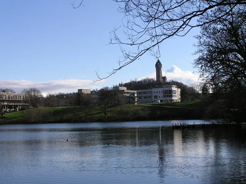
National Wallace Monument, Stirling (Braveheart)
The Victorian tower commemorating William Wallace overlooks the Stirling battlefield central to Braveheart's story; the film itself shot largely in Ireland.
2 km · about 5 min drive
Scotland, United Kingdom · Europe
Stirling works well as a base: 5 minutes from Bannockburn, 32km from Loch Achray and Ben A'an.
Stirling is a town located in Scotland, United Kingdom. With a population of 37,910, it is an important destination in Europe.
On a road trip, Stirling sits in United Kingdom, where you drive on the left. It's in the Europe/London time zone. Below you'll find where to stay, things to do nearby, and everything you need to add Stirling to your route.
Stirling is a city in central Scotland, 26 miles (42 km) north-east of Glasgow and 37 miles (60 km) north-west of Edinburgh. The city is surrounded by rich farmland and had a royal citadel, the medieval old town with its merchants and tradesmen, the Old Bridge and the port are all linked in to its history. Situated onRead more
the River Forth, Stirling is the administrative centre for the Stirling council area, and is traditionally the county town and historic county of Stirlingshire. Stirling's key position as the lowest bridging point of the River Forth before it broadens towards the Firth of Forth made it a focal point for travel north or south. It has been said that "Stirling, like a huge brooch clasps Highlands and Lowlands together". The city's status as "Gateway to the Highlands" also historically lent it great strategic importance—the credo "he who holds Stirling, holds Scotland" is sometimes attributed to Robert the Bruce.
When Stirling was temporarily under Anglo-Saxon sway, according to a 9th-century legend, it was attacked by Danish invaders. The sound of a wolf roused a sentry, however, who alerted his garrison, which forced a Viking retreat. This led to the wolf being adopted as a symbol of the town as is shown on the 1511 Stirling Jug. The area is today known as Wolfcraig. Even today the wolf appears with a goshawk on the council's coat of arms along with the recently chosen motto: "Steadfast as the Rock".
Once the capital of Scotland, Stirling is visually dominated by Stirling Castle. Stirling also has a medieval parish church, the Church of the Holy Rude, where, on 29 July 1567, the infant James VI was anointed King of Scots by Adam Bothwell, the Bishop of Orkney, with the service concluding after a sermon by John Knox. The poet King was educated by George Buchanan and grew up in Stirling. He was later also crowned King of England and Ireland on 25 July 1603, bringing closer the countries of the United Kingdom. Modern Stirling is a centre for local government, higher education, tourism, retail, and industry. The 2022 census for the population of the city is 38,587; the wider Stirling council area has a population of about 93,750.
One of the principal royal strongholds of the Kingdom of Scotland, Stirling was created a royal burgh by David I between 1124 and 1127. In 2002, as part of the Golden Jubilee celebrations, Stirling was granted city status. In the run up to 2024, it was decided to celebrate Stirling's 900th anniversary at the earliest point it could have happened, the coronation of David I.
Compare prices across Booking.com, Airbnb, Expedia, and more. Select your dates to see availability.
Pick your must-haves once: provider links open pre-filtered. Each filter lists which sites it applies to.
Compare before you book!
Prices can vary significantly between platforms. We recommend checking at least 2-3 sites to find the best deal for your stay in Stirling.
Discover famous landmarks, scenic roads, and more near Stirling.
Stirling offers many attractions including tourist sites, museums, parks, and local restaurants. Explore famous landmarks, scenic roads, and natural wonders on our interactive map and plan your visit.
Plan your road trip to Stirling with Plan Your Road Trips! Add Stirling as a destination, and we'll help you find the best route and discover more amazing places along the way.
Stirling is located in Scotland, United Kingdom, Europe. The coordinates are 56.1190 latitude, -3.9368 longitude.
Stirling has a population of approximately 37,910 people, making it a town in United Kingdom.
Add to your itinerary
Start planning your road trip with Stirling as a destination. Create a custom route and discover more amazing places along the way.
Start Road TripDiscover destinations like Tinder
Swipe through stunning destinations near Stirling. Save your favourites and add them to your trip.
Essential numbers in United Kingdom
112 also works. NHS non-emergency medical advice: 111. National Highways breakdown assistance on motorways: 0300 123 5000.
Full driving guide for United Kingdom8 notable places within an hour's drive.
film location
The Victorian tower commemorating William Wallace overlooks the Stirling battlefield central to Braveheart's story; the film itself shot largely in Ireland.
2 km · about 5 min drive
landmark
An outrageous 14m stone pineapple crowns this 1761 walled-garden folly, built for the Earl of Dunmore and rated among Britain's most eccentric buildings. Free to visit, hidden down a lane near Airth.
10 km · about 20 min drive
castle
A well-preserved 14th-century courtyard castle near Stirling, filmed for Monty Python and the Holy Grail, Game of Thrones and Outlander.
10 km · about 20 min drive
film location
The 14th-century keep is Castle Anthrax in Monty Python and the Holy Grail, Castle Leoch in Outlander and Winterfell in the GoT pilot.
10 km · about 20 min drive
landmark
Two 30-metre steel horse-head sculptures towering over the canal at Falkirk, a striking modern landmark off the M9.
16 km · about 30 min drive
photogenic
Scotland's most complete 17th-century burgh: ochre-coloured Culross Palace, cobbled wynds and white-harled cottages on the Firth of Forth, preserved by the National Trust. Doubles as Cranesmuir in Outlander.
20 km · about 25 min drive
racetrack
Scotland's national motorsport centre, a compact but thrilling circuit with sharp elevation changes near Dunfermline.
27 km · about 30 min drive
natural wonder
A small Trossachs loch under Ben A'an, whose short steep path yields one of Scotland's best effort-to-view ratios.
32 km · about 35 min drive
May to September
Far northern latitude: short daylight hours outside summer make long drives harder.
Other places to explore near Stirling.
Create your perfect itinerary with our calendar-based planner. Add stops, discover attractions along the way, and share your trip with friends.
Start Planning