PYRTPlan Your Road Trips
Create TripCommunityMerchandise
PYRTPlan Your Road Trips
Create TripCommunityMerchandise
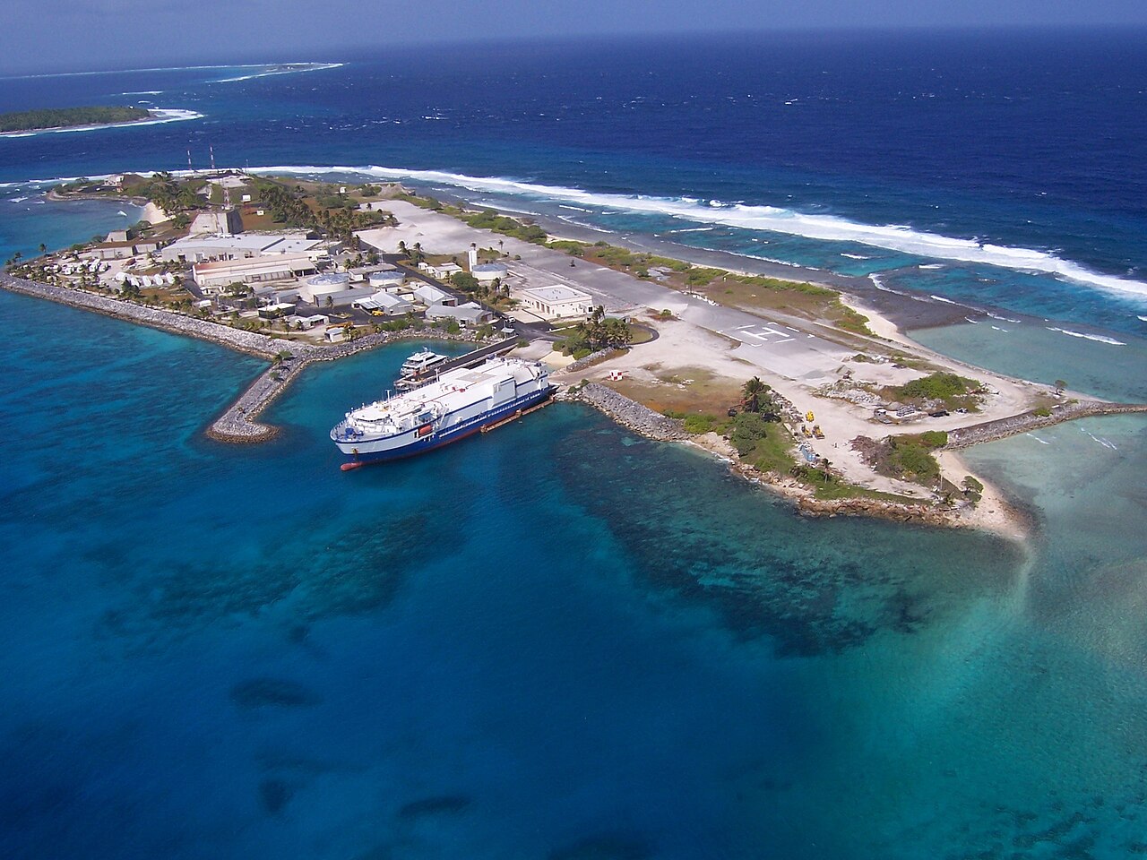
MV Delta Mariner docks at Meck Island with support equipment for use in the Missile Defense Agency's two-stage intermediate/long-range launch vehicle (LV-2) program. These target missiles will be used during agency tests later this year. (2009 official description)
The north-south runway on the right was originally built to accommodate operations by STOL aircraft, notably the De Havilland Canada Caribou and Twin Otter. Strong prevailing winds from the west made for tricky landings and it was later decommissioned. Most transit today is by boat, and the runway area now hosts two helicopter landing pads - only one is seen here, the other appears on photographs as late as 1991 but appears to be decommissioned. The construction area at the south end of the runway (nearer to the camera) is used as a launch site for smaller missiles like THAAD and Patriot.
At the upper part of the the image, framed by the red and white towers, is the main launch area. This was originally built in the 1960s as part of the Sentinel and Safeguard ABM programs. As Meck is only a few feet over sea level, and the missiles were launched from underground silos, the entire area had to be built up into a hill so the silos would not be under water. Seen just below the launch site, although separated by some distance when seen from other angles, is the original Missile Site Radar (MSR) that was built as part of these same tests. The smaller red and white tower on its roof was added later and appears to hold communications gear. The large silver-roofed building to its south hosted the computers, which would normally be under the radar, but were moved here to be above the waterline. The smaller building to the left of the MSR, similarly shaped, is the Site Defense Radar (SDR), essentially a modernized MSR built in the late 1970s. This was built in 1977 on backfilled land that extended the entire area to the west, the former shoreline ran just to the left of the MSR building. Most of the buildings in the photo are from the SDR era or newer, built to support ongoing operations and new launch services.

This image is taken looking roughly north-northeast. The small island in the upper left is Kuwatep, and the longer crescent-shaped one further north is Omelek. Eniwetak is just off frame to the left of Kuwatep. Eniwetak and Omelek host a number of camera sites used to photograph launches from Meck.
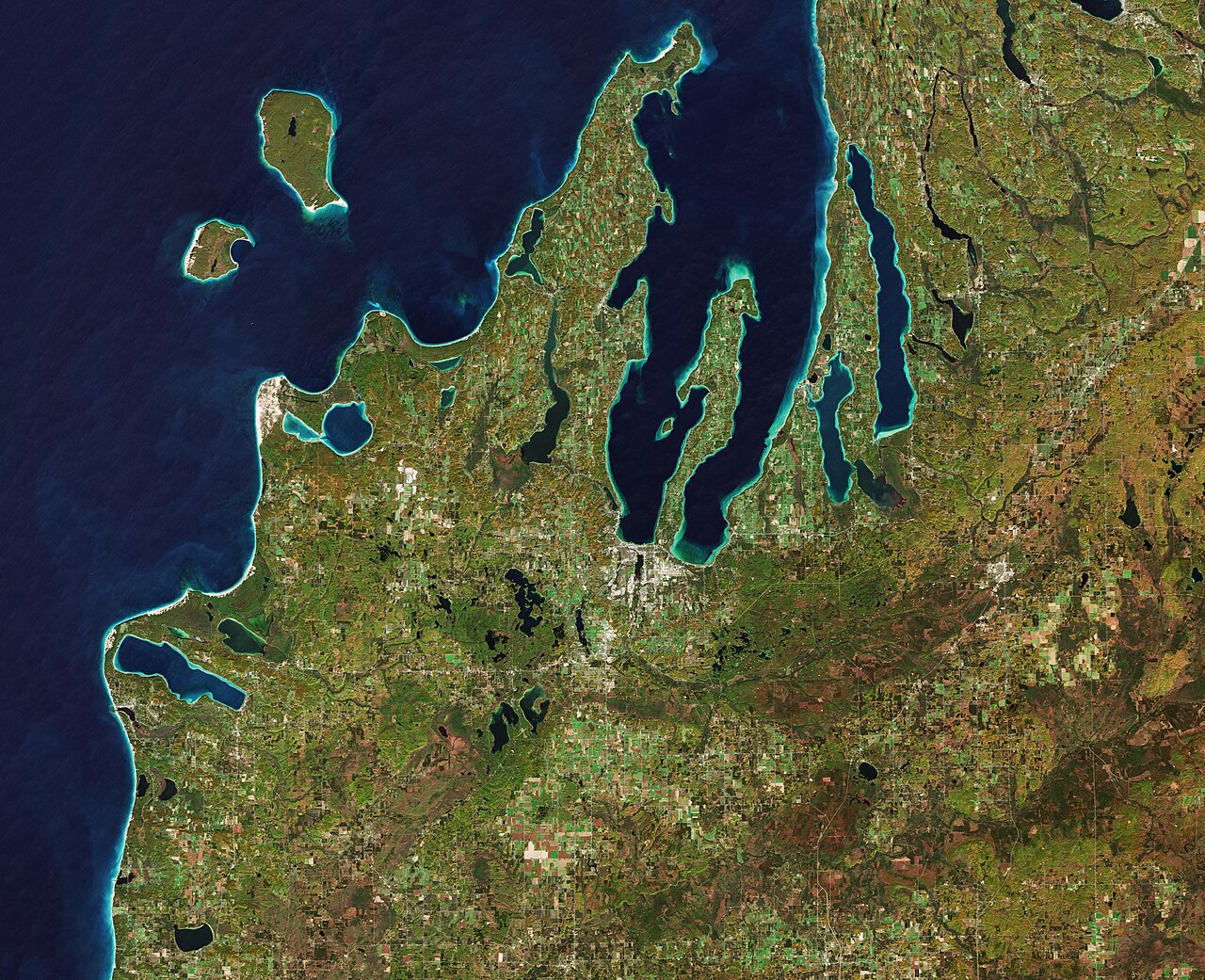
The Copernicus Sentinel-2 mission takes us over the Leelanau Peninsula on the northwest coast of Northern Michigan, US.The region is shaped by rolling hills, large inland lakes shaped by glaciers around 20 000 years ago which form the basis for great farmland. The body of water that surrounds the peninsula is Lake Michigan, one of the five Great Lakes of North America and the only one located entirely within the US.In the image, the bright turquoise in the water shows sediments, algae and chlorophyll in the shallower waters along the shore. The greener colours visible in Lake Leelanau to the north, Platte Lake to the west, and several inland bodies of water are due to a combination of a high chlorophyll and plant content.The Sleeping Bear Dunes Lakeshore extend for around 55 km along the coast of the peninsula, and is visible in light brown. The name comes from an Ojibwa legend in which a mother bear and her two cubs swim across the lake trying to escape a forest fire. The two cubs are said to have disappeared in the process, and the mother bear waited for weeks for them to re-surface before finally falling asleep and never waking. Touched by her suffering, a powerful spirit is said to have covered her with sand, and raised the two cubs above the water, creating the North and South Manitou islands, visible north of the peninsula.A more realistic explanation of the creation of the Sleeping Bear Dunes is geology. During the last Ice Age, glaciers spread southwards from Canada burying this area under sheets of ice. During the process, piles of sand and rock were deposited in the area. When the ice retreated and melted, it left the hilly terrain that exists along the lake today. The area is popular for hiking and climbing.This image, which was captured on 18 October 2018, is also featured on the Earth from Space video programme.
Contains modified Copernicus Sentinel data [2021], processed by <a href="https://twitter.com/Pierre_Markuse" rel="noreferrer nofollow">Pierre Markuse</a>
21 LA-WAPA Wildfire with thick smoke plume, Wapawekka Hills, Saskatchewan, Canada - July 11th, 2021
Image is about 56 kilometers wide.
Check out my blog post with my best and most interesting satellite images of 2020 here <a href="https://pierre-markuse.net/2020/12/31/satellite-images-recap-2020/" rel="noreferrer nofollow">pierre-markuse.net/2020/12/31/satellite-images-recap-2020/</a>.
Do you want to support this collection of satellite images? Any donation, no matter how small, would be appreciated. <a href="https://www.paypal.com/paypalme/PierreMarkuse" rel="noreferrer nofollow">PayPal me!</a>

Follow me on <a href="https://twitter.com/Pierre_Markuse" rel="noreferrer nofollow">Twitter!</a>
Photo by U.S. Missile Defense Agency
Destinations
Home›Destinations›Sentinel Hill
North AmericaCanadaBritish Columbia

Sentinel Hill

British Columbia, Canada · North America

About Sentinel Hill

Sentinel Hill works well as a base: 38km from Sea-to-Sky Highway (BC-99).

Sentinel Hill is a town located in British Columbia, Canada. With a population of 1,060, it is an important destination in North America.

On a road trip, Sentinel Hill sits in Canada, where you drive on the right. It's in the America/Vancouver time zone. Below you'll find where to stay, things to do nearby, and everything you need to add Sentinel Hill to your route.

About Sentinel Hill

École Sentinel Secondary is a secondary school located in West Vancouver, British Columbia, Canada, serving more than 1250 students in Grades 8 through 12. It is one of three public secondary schools in the West Vancouver district (SD #45) including West Vancouver Secondary School and Rockridge Secondary School. The

Read more school has a grass field, two baseball diamonds, three street hockey courts and three tennis courts. The main field is used for some outdoor sports, such as soccer, football, baseball, and rugby. There are also two gyms and a weight room. The school was established for the 1962–63 school year with students who had previously attended Hillside Secondary School and Inglewood Junior High School. The first classes were held in the old Inglewood School until the new building was completed in 1963. The first grade 12 graduating class was in 1965. The school is on 1200 Chartwell Drive, sitting beside an elementary school Chartwell Elementary.

Read more on Wikipedia

Where to Stay in Sentinel Hill

Compare prices across Booking.com, Airbnb, Expedia, and more. Select your dates to see availability.

Filter presets

Pick your must-haves once: provider links open pre-filtered. Each filter lists which sites it applies to.

Booking.comExpediaTripAdvisorHotels.comAgodaAirbnb

Compare before you book!

Prices can vary significantly between platforms. We recommend checking at least 2-3 sites to find the best deal for your stay in Sentinel Hill.

Explore the Area

Discover famous landmarks, scenic roads, and more near Sentinel Hill.

Loading map...
Open in Google Maps

Frequently Asked Questions

What are the best things to do in Sentinel Hill?

Sentinel Hill offers many attractions including tourist sites, museums, parks, and local restaurants. Explore famous landmarks, scenic roads, and natural wonders on our interactive map and plan your visit.

How do I plan a road trip to Sentinel Hill?

Plan your road trip to Sentinel Hill with Plan Your Road Trips! Add Sentinel Hill as a destination, and we'll help you find the best route and discover more amazing places along the way.

Where is Sentinel Hill located?

Sentinel Hill is located in British Columbia, Canada, North America. The coordinates are 49.3373 latitude, -123.1460 longitude.

What is the population of Sentinel Hill?

Sentinel Hill has a population of approximately 1,060 people, making it a town in Canada.

Plan a Road Trip

Add to your itinerary

Start planning your road trip with Sentinel Hill as a destination. Create a custom route and discover more amazing places along the way.

Start Road Trip

What's Nearby?

Discover destinations like Tinder

Swipe through stunning destinations near Sentinel Hill. Save your favourites and add them to your trip.

Explore now

Quick Information

Population
1,060
Continent
North America
Country
Canada
Region
British Columbia
Timezone
America/Vancouver
Coordinates
49.3373, -123.1460

Emergency & Services

Essential numbers in Canada

Police
911
Ambulance
911
Fire
911
Driving side
right

CAA roadside assistance: 1-800-222-4357. Winter tyres mandatory in Quebec December–March.

Full driving guide for Canada

Tags

North AmericaCanadaBritish ColumbiaTown

Worth the detour from Sentinel Hill

8 notable places within an hour's drive.

bridge

Capilano Suspension Bridge

A 137 m footbridge swaying 70 m above the Capilano River in North Vancouver, with treetop walkways and a granite cliffwalk: one of BC's most visited attractions since 1889.

2 km · about 5 min drive

bridge

Lions Gate Bridge

Vancouver's iconic 1938 suspension bridge spanning the First Narrows from Stanley Park to the North Shore, gateway to the Sea-to-Sky Highway with mountain and harbour views from its green towers.

3 km · about 5 min drive

landmark

Vancouver Aquarium

Canada's largest aquarium in Stanley Park dedicated to the conservation of aquatic life in the Pacific Northwest.

4 km · about 10 min drive

landmark

Stanley Park Totem Poles

Collection of First Nations totem poles in Vancouver's Stanley Park, one of the most visited attractions in British Columbia.

5 km · about 10 min drive

scenic viewpoint

Sea-to-Sky Highway

Stunning coastal and mountain highway from Vancouver to Whistler

30 km · about 35 min drive

waterfall

Shannon Falls

British Columbia's third-highest waterfall, immediately beside the Sea to Sky Highway near Squamish with a roadside car park.

37 km · about 45 min drive

scenic viewpoint

Sea to Sky Gondola

Gondola beside the Sea-to-Sky Highway near Squamish, rising 885 m above Howe Sound to a summit lodge, suspension bridge and sweeping viewpoints over fjord, forest and the Stawamus Chief.

38 km · about 45 min drive

famous road

Sea-to-Sky Highway (BC-99)

From Vancouver's Howe Sound to Whistler, rebuilt for the 2010 Olympics, with fjord views the whole way.

38 km · about 45 min drive

Driving roads near Sentinel Hill

  • Right hereCapilano Suspension BridgeA 137 m footbridge swaying 70 m above the Capilano River in North Vancouver, with treetop walkways and a granite cliffwalk: one of BC's most visited attractions since 1889.
  • Right hereLions Gate BridgeVancouver's iconic 1938 suspension bridge spanning the First Narrows from Stanley Park to the North Shore, gateway to the Sea-to-Sky Highway with mountain and harbour views from its green towers.
  • 30 kmSea-to-Sky HighwayStunning coastal and mountain highway from Vancouver to Whistler
  • 38 kmSea to Sky GondolaGondola beside the Sea-to-Sky Highway near Squamish, rising 885 m above Howe Sound to a summit lodge, suspension bridge and sweeping viewpoints over fjord, forest and the Stawamus Chief.
  • 38 kmSea-to-Sky Highway (BC-99)From Vancouver's Howe Sound to Whistler, rebuilt for the 2010 Olympics, with fjord views the whole way.

Nearby Destinations

Other places to explore near Sentinel Hill.

Ambleside

🇨🇦 Canada

1 km awayPop. 11,998

Chartwell

🇨🇦 Canada

1 km awayPop. 1,383

West Vancouver

🇨🇦 Canada

1 km awayPop. 45,487

Capilano

🇨🇦 Canada

3 km awayPop. 3,177

Edgemont Village

🇨🇦 Canada

3 km awayPop. 1,213

Glenmore

🇨🇦 Canada

3 km awayPop. 1,028

Highlands

🇨🇦 Canada

4 km awayPop. 2,885

Delbrook

🇨🇦 Canada

5 km awayPop. 2,497

Plan a trip around Sentinel Hill

North America road trip planner

Plan a Road Trip from Sentinel Hill

Create your perfect itinerary with our calendar-based planner. Add stops, discover attractions along the way, and share your trip with friends.

Start Planning
PYRT

The ultimate road trip planning platform. Discover 150,000+ destinations worldwide, plan scenic routes, and create unforgettable adventures.

Inspiration

  • Discover Trips
  • Travel Guides
  • Community

The Product

  • Calendar Planner
  • Integrations
  • How It Works
  • Collaboration Mode
  • Get the App
  • Merchandise: PYRT Supply Co.
  • Become a Creator
  • Trip Marketplace

Plan Your Trip

  • Road Trip Planner
  • Famous Routes
  • Drive Times & Distances
  • Planners by Country
  • Best Road Trip Planner App
  • Discover Road Trips
  • Events
  • Travel Guides
  • How It Works
  • My Trips
  • Community Groups

Company

  • Terms of Service
  • Privacy Policy
  • Support
  • Contact Us
  • Sign In
  • Create Account

© 2026 Plan Your Road Trips. All rights reserved.

•[email protected]
Data sources:GeoNames (CC BY 4.0)•Wikimedia Commons (CC BY-SA)•Mapbox•Photography: George Lawrence