racetrack
Circuit Paul Ricard
French Formula 1 circuit near the Côte d'Azur famous for its distinctive blue and red run-off stripes.
23 km · about 25 min drive


Provence-Alpes-Côte d'Azur, France · Europe
Saint-Maximin-la-Sainte-Baume is worth a stop: 10 minutes from Rougiers, 42km from Calanques National Park.
Saint-Maximin-la-Sainte-Baume is a town located in Provence-Alpes-Côte d'Azur, France. With a population of 15,225, it is an important destination in Europe.
On a road trip, Saint-Maximin-la-Sainte-Baume sits in France, where you drive on the right. It's in the Europe/Paris time zone. Below you'll find where to stay, things to do nearby, and everything you need to add Saint-Maximin-la-Sainte-Baume to your route.
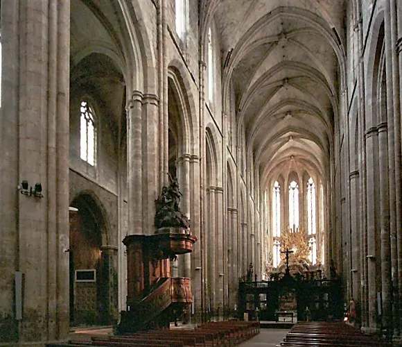
Saint-Maximin-la-Sainte-Baume (French pronunciation: [sɛ̃ maksimɛ̃ la sɛ̃t bom]; Occitan: Sant Maissemin de la Santa Bauma) is a commune in the southeastern French department of Var, in the Provence-Alpes-Côte d'Azur region. Located 40 km (25 mi) east of Aix-en-Provence, the town lies at the foot of the Sainte-BaumeRead more
mountains. Baume or bama is the Provençal equivalent of cave. The town's basilica is dedicated to Mary Magdalene.
Compare prices across Booking.com, Airbnb, Expedia, and more. Select your dates to see availability.
Pick your must-haves once: provider links open pre-filtered. Each filter lists which sites it applies to.
Compare before you book!
Prices can vary significantly between platforms. We recommend checking at least 2-3 sites to find the best deal for your stay in Saint-Maximin-la-Sainte-Baume.
Discover famous landmarks, scenic roads, and more near Saint-Maximin-la-Sainte-Baume.
Saint-Maximin-la-Sainte-Baume offers many attractions including tourist sites, museums, parks, and local restaurants. Explore famous landmarks, scenic roads, and natural wonders on our interactive map and plan your visit.
Plan your road trip to Saint-Maximin-la-Sainte-Baume with Plan Your Road Trips! Add Saint-Maximin-la-Sainte-Baume as a destination, and we'll help you find the best route and discover more amazing places along the way.
Saint-Maximin-la-Sainte-Baume is located in Provence-Alpes-Côte d'Azur, France, Europe. The coordinates are 43.4481 latitude, 5.8608 longitude.
Saint-Maximin-la-Sainte-Baume has a population of approximately 15,225 people, making it a town in France.
Add to your itinerary
Start planning your road trip with Saint-Maximin-la-Sainte-Baume as a destination. Create a custom route and discover more amazing places along the way.
Start Road TripDiscover destinations like Tinder
Swipe through stunning destinations near Saint-Maximin-la-Sainte-Baume. Save your favourites and add them to your trip.
Essential numbers in France
Carrying a warning triangle and hi-vis vest in your vehicle is mandatory. Motorway emergency phones connect to official breakdown services only.
Full driving guide for France8 notable places within an hour's drive.
racetrack
French Formula 1 circuit near the Côte d'Azur famous for its distinctive blue and red run-off stripes.
23 km · about 25 min drive
scenic viewpoint
A 584 m limestone mountain looming over Toulon, climbed by a narrow corniche road of tight hairpins beloved of the Tour de France; the summit offers superb views over one of Europe's finest natural harbours.
34 km · about 40 min drive
coastal drive
A clifftop corniche from Cassis to La Ciotat climbing the highest sea cliffs in France with stunning overlooks.
36 km · about 40 min drive
beach
The most beautiful of the Calanques, a slender turquoise inlet hemmed by needle-sharp white pinnacles.
39 km · about 45 min drive
national park
Dramatic limestone fjord-like inlets with turquoise waters and white cliffs stretching between Marseille and Cassis on the Mediterranean coast.
42 km · about 50 min drive
natural wonder
A vivid turquoise reservoir at the mouth of the Verdon gorge, perfect for pedal-boats and a swim.
43 km · about 50 min drive
scenic viewpoint
Vast purple lavender plateaus that bloom spectacularly from mid-June to mid-August across the Valensole plain.
44 km · about 50 min drive
scenic viewpoint
Marseille's 'Bonne Mere' basilica crowns a 149 m limestone peak reachable by a winding drive, with a sweeping 360-degree panorama over the Old Port, the Frioul islands and the Calanques.
44 km · about 50 min drive
April to October
Other places to explore near Saint-Maximin-la-Sainte-Baume.
Create your perfect itinerary with our calendar-based planner. Add stops, discover attractions along the way, and share your trip with friends.
Start Planning