mountain pass
Col de la Forclaz (Valais)
The pass above Martigny on the road to Chamonix, kept open all year and a natural gateway to the Mont Blanc valleys.
7 km · about 15 min drive
Valais, Switzerland · Europe
Martigny-Ville works well as a base: 10 minutes from Salvan, 12km from Lac d'Emosson.
Martigny-Ville is a town located in Valais, Switzerland. With a population of 18,301, it is an important destination in Europe.
On a road trip, Martigny-Ville sits in Switzerland, where you drive on the right. It's in the Europe/Zurich time zone. Below you'll find where to stay, things to do nearby, and everything you need to add Martigny-Ville to your route.
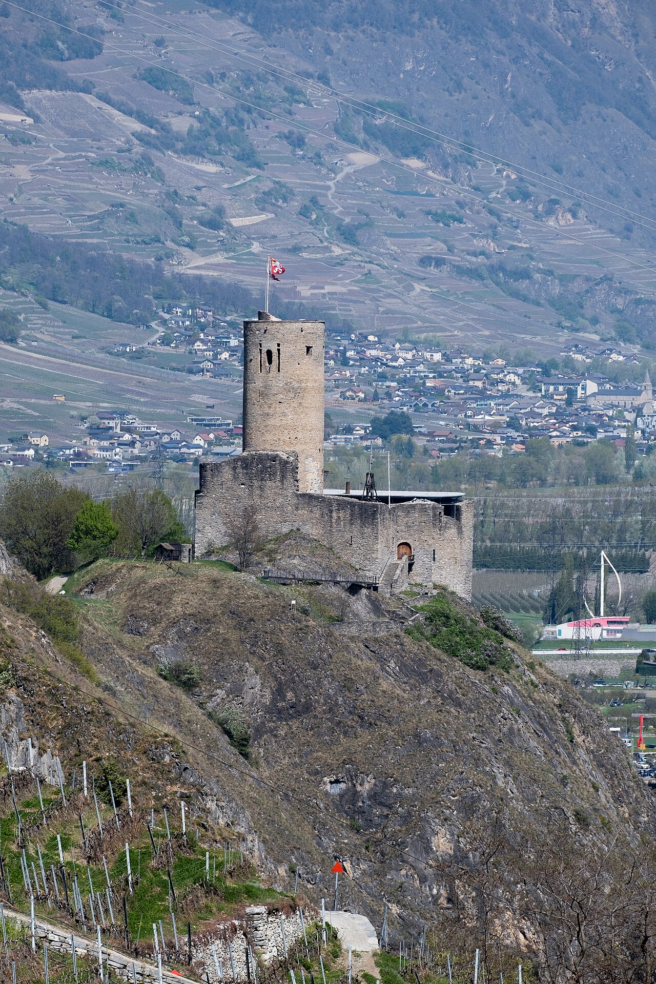
La Bâtiaz Castle (French: Château de la Bâtiaz) is a castle in the municipality of Martigny, in the Canton of Valais, Switzerland. It is a Swiss heritage site of national significance.
The garderobes (toilets) at La Bâtiaz played a part in determining that the architect for some UNESCO listed castles in Wales cameRead more
from Savoy. Historian and custodian A. J. Taylor travelled to La Bâtiaz and noticed that the castle and the one at Harlech shared a specific unique feature in toilet design. The discovery enabled Taylor to confirm that James of Saint George had been the architect of both.
Compare prices across Booking.com, Airbnb, Expedia, and more. Select your dates to see availability.
Pick your must-haves once: provider links open pre-filtered. Each filter lists which sites it applies to.
Compare before you book!
Prices can vary significantly between platforms. We recommend checking at least 2-3 sites to find the best deal for your stay in Martigny-Ville.
Discover famous landmarks, scenic roads, and more near Martigny-Ville.
Martigny-Ville offers many attractions including tourist sites, museums, parks, and local restaurants. Explore famous landmarks, scenic roads, and natural wonders on our interactive map and plan your visit.
Plan your road trip to Martigny-Ville with Plan Your Road Trips! Add Martigny-Ville as a destination, and we'll help you find the best route and discover more amazing places along the way.
Martigny-Ville is located in Valais, Switzerland, Europe. The coordinates are 46.1028 latitude, 7.0724 longitude.
Martigny-Ville has a population of approximately 18,301 people, making it a town in Switzerland.
Add to your itinerary
Start planning your road trip with Martigny-Ville as a destination. Create a custom route and discover more amazing places along the way.
Start Road TripDiscover destinations like Tinder
Swipe through stunning destinations near Martigny-Ville. Save your favourites and add them to your trip.
Essential numbers in Switzerland
Motorway vignette (toll sticker) required: buy at the border or online. Roadside assistance (TCS): 140.
Full driving guide for Switzerland8 notable places within an hour's drive.
mountain pass
The pass above Martigny on the road to Chamonix, kept open all year and a natural gateway to the Mont Blanc valleys.
7 km · about 15 min drive
natural wonder
A high dam lake reached by a steep dead-end road, facing directly across to the Mont Blanc massif. Dinosaur trackways lie on the slabs above it.
12 km · about 20 min drive
natural wonder
France's largest glacier, reached by a red rack railway from Chamonix to walk into an ice cave.
23 km · about 25 min drive
waterfall
Known as the 'Queen of the Alps,' this dramatic 90-meter double waterfall cascades down a cliff face in Haute-Savoie.
25 km · about 30 min drive
landmark
The legendary Alpine resort town nestled at the foot of Mont Blanc, Europe's highest peak at 4,808 meters.
25 km · about 30 min drive
landmark
At 285 m the world's tallest gravity dam seals the Val d'Hérémence with more concrete than the Great Pyramid; a cable car rides to the crest, with guided gallery tours and a zip line across the wall.
26 km · about 30 min drive
mountain pass
At 2,469 m, this ancient pass between Switzerland and Italy shelters the hospice that bred St Bernard rescue dogs; travellers have crossed here since Roman times, Napoleon among them.
27 km · about 30 min drive
famous road
The historic 2,469m pass between Switzerland and Italy with its hospice and dogs; the old road runs beside the modern tunnel.
27 km · about 30 min drive
8 named roads, passes and coastal drives within 60km.
April to October
Other places to explore near Martigny-Ville.
Create your perfect itinerary with our calendar-based planner. Add stops, discover attractions along the way, and share your trip with friends.
Start Planning