
museum
Franschhoek Motor Museum
Elegant museum in the Cape Winelands housing over 220 vehicles from an 1898 Beeston to modern supercars.
6 km · about 10 min drive
Western Cape, South Africa · Africa
Kylemore is worth a stop: 15 minutes from Stellenbosch, 49km from N1/N4 Cape Town to Kruger.
Kylemore is a town located in Western Cape, South Africa. With a population of 5,185, it is an important destination in Africa.
On a road trip, Kylemore sits in South Africa, where you drive on the left. It's in the Africa/Johannesburg time zone. Below you'll find where to stay, things to do nearby, and everything you need to add Kylemore to your route.
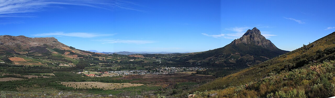
Kylemore is a village in the Western Cape of South Africa. It is located in the Cape Winelands, within Helshoogte Pass on the route from Stellenbosch to Franschhoek. It was founded by Kyle Mohr in 1955.
With a population of 4000+ people, the community is largely dependent on employment in the bigger towns,Read more
predominantly Stellenbosch, Paarl, and greater Cape Town. The adjacent farms provide seasonal jobs to farm labourers and students during the harvest season.
The town is surrounded by mountains and rivers, with walking trails into the neighboring countryside. Rugby is the most popular sport in the village.
Compare prices across Booking.com, Airbnb, Expedia, and more. Select your dates to see availability.
Pick your must-haves once: provider links open pre-filtered. Each filter lists which sites it applies to.
Compare before you book!
Prices can vary significantly between platforms. We recommend checking at least 2-3 sites to find the best deal for your stay in Kylemore.
Discover famous landmarks, scenic roads, and more near Kylemore.
Kylemore offers many attractions including tourist sites, museums, parks, and local restaurants. Explore famous landmarks, scenic roads, and natural wonders on our interactive map and plan your visit.
Plan your road trip to Kylemore with Plan Your Road Trips! Add Kylemore as a destination, and we'll help you find the best route and discover more amazing places along the way.
Kylemore is located in Western Cape, South Africa, Africa. The coordinates are -33.9151 latitude, 18.9503 longitude.
Kylemore has a population of approximately 5,185 people, making it a town in South Africa.
Add to your itinerary
Start planning your road trip with Kylemore as a destination. Create a custom route and discover more amazing places along the way.
Start Road TripDiscover destinations like Tinder
Swipe through stunning destinations near Kylemore. Save your favourites and add them to your trip.
Essential numbers in South Africa
112 works from mobiles. Avoid driving at night in rural areas; keep doors locked in cities.
Full driving guide for South Africa8 notable places within an hour's drive.
museum
Elegant museum in the Cape Winelands housing over 220 vehicles from an 1898 Beeston to modern supercars.
6 km · about 10 min drive
mountain pass
A sweeping tarred climb out of the Franschhoek wine valley on the R45, following an old elephant migration route and offering a lay-by view back over the vineyard-filled bowl. Quick to drive and a favourite of Cape Town car clubs.
19 km · about 20 min drive
tunnel
South Africa's longest road tunnel, boring 3.9 km through the Du Toitskloof mountains on the N1 near Paarl and bypassing the old scenic pass above it.
24 km · about 30 min drive
coastal drive
A cliff-hugging coastal road between Gordon's Bay and Rooi-Els along False Bay, rated among the world's great ocean drives, with whale sightings in season.
35 km · about 40 min drive
historic highway
An 1853 Thomas Bain pass that runs as a narrow ledge blasted into the mountainside above the Witte River, barely altered since construction and now a national monument. The tarred road is single-lane in places with dramatic drop-offs.
36 km · about 40 min drive
museum
Africa's largest contemporary art museum, carved from a historic grain silo on Cape Town's waterfront.
49 km · about 55 min drive
beach
A family-friendly Cape Town beach famous for its colourful Victorian bathing boxes and gentle waves perfect for learning to surf.
49 km · about 55 min drive
famous road
South Africa's grand traverse from the Cape Winelands across the Karoo to Kruger National Park and its Big Five wildlife.
49 km · about 55 min drive
Other places to explore near Kylemore.
Create your perfect itinerary with our calendar-based planner. Add stops, discover attractions along the way, and share your trip with friends.
Start Planning