PYRTPlan Your Road Trips
Create TripCommunityMerchandise
PYRTPlan Your Road Trips
Create TripCommunityMerchandise
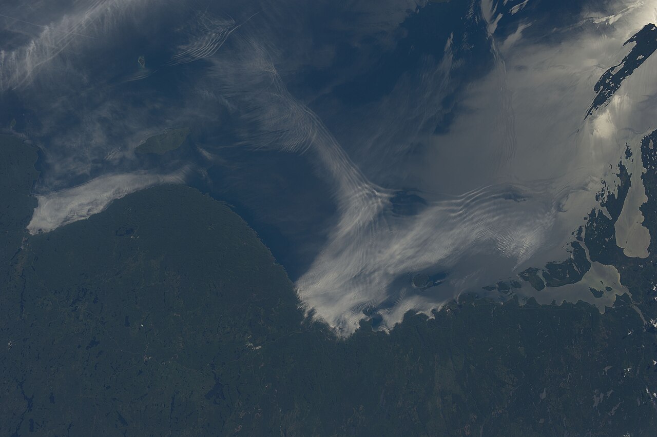
Gravity waves and sunglint on Lake Superior are featured in this image photographed by an Expedition 36 crew member on the International Space Station.
From the vantage point of the space station, crew members frequently observe Earth atmospheric and surface phenomena in ways impossible to view from the ground. Two such phenomena gravity waves and sunglint are illustrated in this photograph of northeastern Lake Superior.
The Canadian Shield of southern Ontario (bottom) is covered with extensive green forest canopy typical of early summer. Offshore, and to the west and southwest of Pukaskwa National Park several distinct sets of parallel cloud bands are visible. Gravity waves are produced when moisture-laden air encounters imbalances in air density, such as might be expected when cool air flows over warmer air; this can cause the flowing air to oscillate up and down as it moves, causing clouds to condense as the air rises (cools) and evaporate away as the air sinks (warms). This produces parallel bands of clouds oriented perpendicular to the wind direction. The orientation of the cloud bands visible in this image, parallel to the coastlines, suggests that air flowing off of the land surfaces to the north is interacting with moist, stable air over the lake surface, creating gravity waves.
The second phenomenon sunglint effects the water surface around and to the northeast of Isle Royale (upper right). Sunglint is caused by light reflection off a water surface; some of the reflected light travels directly back towards the observer, resulting in a bright mirror-like appearance over large expanses of water. Water currents and changes in surface tension (typically caused by presence of oils or surfactants) alter the reflective properties of the water, and can be highlighted by sunglint. For example, surface water currents are visible to the east of Isle Royale that are oriented similarly to the gravity waves – suggesting that they too are the product of winds moving off of the land surface.
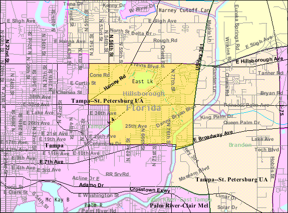
U.S. Census 2000 reference map for East Lake-Orient Park
Category:Census Bureau images
Category:Florida maps
Commons:Category:PD US Census

Commons:Category:Maps of Florida
Kolob Canyons, also referred to as the Finger Canyons of the Kolob, occur in the northwestern corner of Zion National Park in southwestern Utah, USA.
Kolob Canyons occur immediately east of the Hurricane Cliffs, which sit at the western boundary of the Colorado Plateau Physiographic Province.  As is the rest of the Colorado Plateau, Zion Park and the Kolob Canyons area consist of ~horizontally-oriented sedimentary rocks.  In the Zion Park area, the rocks are almost entirely Mesozoic in age.
The main scenery-making unit at Kolob Canyons is the cliff-forming Navajo Sandstone (Lower Jurassic, possibly Upper Triassic? as well).  The Navajo is a thick, cross-bedded, eolian quartzose sandstone deposit representing migrating sand dunes in an ancient sand sea (erg facies).  The reddish coloration is due to hematite cement and hematite staining (hematite = Fe2O3).  In places, the Navajo Sandstone lacks hematite staining and is whitish-colored.
Bottom-up weathering and erosion of Navajo Sandstone cliffs has produced blind arches in places, which are large, arch-shaped structures.
Differential weathering and erosion has produced a pitted surface on some Navajo Sandstone cliff faces - this is honeycomb weathering.  Honeycomb weathering is common in just about any cliff-forming sandstone unit.
Underlying the Navajo Sandstone is the Kayenta Formation (?Upper Triassic to Lower Jurassic).  The Kayenta consists of fluvial redbeds (reddish-colored, hematite-rich siliciclastic sedimentary rocks such as shale, siltstone, and sandstone deposited in river and floodplain environments).  The next unit down is the Moenave Formation (Upper Triassic), also consisting of nonmarine redbeds. representing stream, floodplain, and lake deposits.
In the Kolob Canyons area, the Kayenta and Moenave Formations are noticeably tilted due to their proximity to the tectonic boundary between the Colorado Plateau and the Basin and Range.  Minor faulting has occurred and several Kayenta-Moenave roadcuts along Kolob Canyons Road show nice normal faults.

The light of a setting Sun turns the Navajo Sandstone cliffs ablaze with fiery orangish-red coloration.  This effect can be experienced in several American national parks.
Photo by NASA
Destinations
Home›Destinations›East Lake-Orient Park
North AmericaUnited StatesFlorida

East Lake-Orient Park

Florida, United States · North America

About East Lake-Orient Park

East Lake-Orient Park is worth a stop: 10 minutes from Temple Terrace, 44km from Clearwater Beach.

East Lake-Orient Park is a town located in Florida, United States. With a population of 22,753, it is an important destination in North America.

On a road trip, East Lake-Orient Park sits in United States, where you drive on the right. It's in the America/New York time zone. Below you'll find where to stay, things to do nearby, and everything you need to add East Lake-Orient Park to your route.

About East Lake-Orient Park

Cristo Rey Tampa Salesian High School is a Catholic college-preparatory school and work study program sponsored by the Salesians of Don Bosco. Opened in 2016, it is a part of the national Cristo Rey Network of schools whose goal is to educate students from lower income families and provide the opportunity to attend

Read more college. To be admitted, students must meet financial need guidelines and rigorous academic standards. The school offers a program where students can gain real-world work experience across many different professional fields, and develop workplace readiness skills as well as confidence and aspiration for college and career success.

Read more on Wikipedia

Where to Stay in East Lake-Orient Park

Compare prices across Booking.com, Airbnb, Expedia, and more. Select your dates to see availability.

Filter presets

Pick your must-haves once: provider links open pre-filtered. Each filter lists which sites it applies to.

Booking.comExpediaTripAdvisorHotels.comAgodaAirbnb

Compare before you book!

Prices can vary significantly between platforms. We recommend checking at least 2-3 sites to find the best deal for your stay in East Lake-Orient Park.

Explore the Area

Discover famous landmarks, scenic roads, and more near East Lake-Orient Park.

Loading map...
Open in Google Maps

Frequently Asked Questions

What are the best things to do in East Lake-Orient Park?

East Lake-Orient Park offers many attractions including tourist sites, museums, parks, and local restaurants. Explore famous landmarks, scenic roads, and natural wonders on our interactive map and plan your visit.

How do I plan a road trip to East Lake-Orient Park?

Plan your road trip to East Lake-Orient Park with Plan Your Road Trips! Add East Lake-Orient Park as a destination, and we'll help you find the best route and discover more amazing places along the way.

Where is East Lake-Orient Park located?

East Lake-Orient Park is located in Florida, United States, North America. The coordinates are 27.9827 latitude, -82.3788 longitude.

What is the population of East Lake-Orient Park?

East Lake-Orient Park has a population of approximately 22,753 people, making it a town in United States.

Plan a Road Trip

Add to your itinerary

Start planning your road trip with East Lake-Orient Park as a destination. Create a custom route and discover more amazing places along the way.

Start Road Trip

What's Nearby?

Discover destinations like Tinder

Swipe through stunning destinations near East Lake-Orient Park. Save your favourites and add them to your trip.

Explore now

Quick Information

Population
22,753
Continent
North America
Country
United States
Region
Florida
Timezone
America/New_York
Coordinates
27.9827, -82.3788

Emergency & Services

Essential numbers in United States

Police
911
Ambulance
911
Fire
911
Driving side
right

AAA roadside assistance: 1-800-222-4357. Right turn on red is legal in most states unless signed otherwise.

Full driving guide for United States

Tags

North AmericaUnited StatesFloridaTown

Worth the detour from East Lake-Orient Park

3 notable places within an hour's drive.

landmark

Busch Gardens Tampa Bay

African-themed park combining world-class thrill rides with one of North America's largest zoos.

7 km · about 15 min drive

beach

Clearwater Beach

A pristine Gulf Coast barrier island beach with sugar-white sand, calm warm waters, and spectacular sunsets.

44 km · about 50 min drive

bridge

Sunshine Skyway Bridge

A soaring cable-stayed bridge carrying I-275 over Tampa Bay, its 430-foot yellow-cabled main span a Florida icon; fishing piers on the old bridge approaches flank the crossing.

49 km · about 55 min drive

Driving roads near East Lake-Orient Park

  • 49 kmSunshine Skyway BridgeA soaring cable-stayed bridge carrying I-275 over Tampa Bay, its 430-foot yellow-cabled main span a Florida icon; fishing piers on the old bridge approaches flank the crossing.

Nearby Destinations

Other places to explore near East Lake-Orient Park.

Progress Village

🇺🇸 United States

9 km awayPop. 5,392

Brandon

🇺🇸 United States

10 km awayPop. 103,483

Riverview

🇺🇸 United States

14 km awayPop. 71,050

Keystone

🇺🇸 United States

31 km awayPop. 24,039

Plan a trip around East Lake-Orient Park

North America road trip planner

Plan a Road Trip from East Lake-Orient Park

Create your perfect itinerary with our calendar-based planner. Add stops, discover attractions along the way, and share your trip with friends.

Start Planning
PYRT

The ultimate road trip planning platform. Discover 150,000+ destinations worldwide, plan scenic routes, and create unforgettable adventures.

Inspiration

  • Discover Trips
  • Travel Guides
  • Community

The Product

  • Calendar Planner
  • Integrations
  • How It Works
  • Collaboration Mode
  • Get the App
  • Merchandise: PYRT Supply Co.
  • Become a Creator
  • Trip Marketplace

Plan Your Trip

  • Road Trip Planner
  • Famous Routes
  • Drive Times & Distances
  • Planners by Country
  • Best Road Trip Planner App
  • Discover Road Trips
  • Events
  • Travel Guides
  • How It Works
  • My Trips
  • Community Groups

Company

  • Terms of Service
  • Privacy Policy
  • Support
  • Contact Us
  • Sign In
  • Create Account

© 2026 Plan Your Road Trips. All rights reserved.

•[email protected]
Data sources:GeoNames (CC BY 4.0)•Wikimedia Commons (CC BY-SA)•Mapbox•Photography: George Lawrence