bridge
Capilano Suspension Bridge
A 137 m footbridge swaying 70 m above the Capilano River in North Vancouver, with treetop walkways and a granite cliffwalk: one of BC's most visited attractions since 1889.
12 km · about 25 min drive
British Columbia, Canada · North America
Dollarton works well as a base: 5 minutes from Westridge, 43km from Sea-to-Sky Highway (BC-99).
Dollarton is a town located in British Columbia, Canada. With a population of 2,692, it is an important destination in North America.
On a road trip, Dollarton sits in Canada, where you drive on the right. It's in the America/Vancouver time zone. Below you'll find where to stay, things to do nearby, and everything you need to add Dollarton to your route.
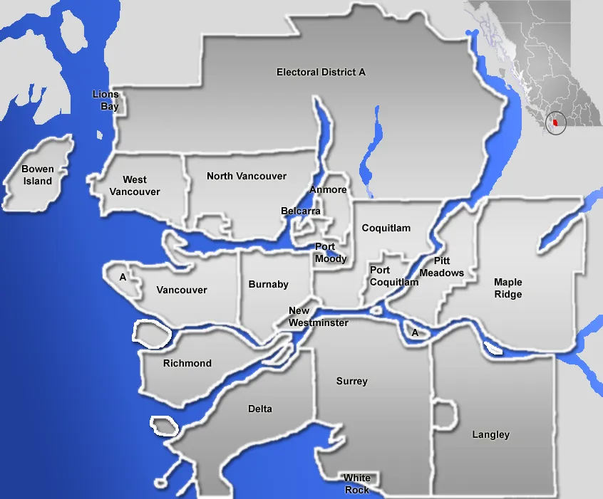
Dollarton is a neighborhood in the municipal district of North Vancouver, British Columbia, Canada. It was founded in 1916 as the site of a sawmill and a village for sawmill workers by Robert Dollar, a San Francisco businessman. Already at this time Dollarton was part of the District Municipality of North Vancouver.Read more
In 1917 The Deep Cove Lumber Company began logging the east side of Mount Seymour supplying logs to local mills. In 1918 a road connection was provided to connect it to the rest of the municipality and the more recently created City of North Vancouver. This road was likely an extension of Keith Road which stretched from Horseshoe Bay to Deep Cove. A later road connection known as the Dollarton Highway was completed in 1931. In 1936 Mount Seymour Park was established. In 1942 the Dollarton sawmill was closed. Since that time Dollarton and the surrounding area has developed as a residential and recreational area. In 1948 a road was built up Mount Seymour to develop a ski area. Sometime between 1955 and 1958 a large municipal park, Cates Park, was established in South Dollarton on Burrard Inlet. Since the closure of the sawmill the area to become Cates Park had developed into a desirable squatter community consisting of reasonably well build cabins. Upon creation of the Cates Park the residents were evicted. Native communities who had a village in the area are also reclaiming some ownership over the land beyond the designated Indian Reserves further west along the shore of Burrard Inlet. Besides developing as a residential area, Dollarton, along with Mount Seymour and the adjoining Neighborhood of Deep Cove offer recreational opportunities for people from all over the Vancouver Lower Mainland. The area is generally referred to as Deep Cove by non-residents.
Compare prices across Booking.com, Airbnb, Expedia, and more. Select your dates to see availability.
Pick your must-haves once: provider links open pre-filtered. Each filter lists which sites it applies to.
Compare before you book!
Prices can vary significantly between platforms. We recommend checking at least 2-3 sites to find the best deal for your stay in Dollarton.
Discover famous landmarks, scenic roads, and more near Dollarton.
Dollarton offers many attractions including tourist sites, museums, parks, and local restaurants. Explore famous landmarks, scenic roads, and natural wonders on our interactive map and plan your visit.
Plan your road trip to Dollarton with Plan Your Road Trips! Add Dollarton as a destination, and we'll help you find the best route and discover more amazing places along the way.
Dollarton is located in British Columbia, Canada, North America. The coordinates are 49.3167 latitude, -122.9500 longitude.
Dollarton has a population of approximately 2,692 people, making it a town in Canada.
Add to your itinerary
Start planning your road trip with Dollarton as a destination. Create a custom route and discover more amazing places along the way.
Start Road TripDiscover destinations like Tinder
Swipe through stunning destinations near Dollarton. Save your favourites and add them to your trip.
Essential numbers in Canada
CAA roadside assistance: 1-800-222-4357. Winter tyres mandatory in Quebec December–March.
Full driving guide for Canada8 notable places within an hour's drive.
bridge
A 137 m footbridge swaying 70 m above the Capilano River in North Vancouver, with treetop walkways and a granite cliffwalk: one of BC's most visited attractions since 1889.
12 km · about 25 min drive
landmark
Collection of First Nations totem poles in Vancouver's Stanley Park, one of the most visited attractions in British Columbia.
13 km · about 25 min drive
landmark
Canada's largest aquarium in Stanley Park dedicated to the conservation of aquatic life in the Pacific Northwest.
13 km · about 25 min drive
bridge
Vancouver's iconic 1938 suspension bridge spanning the First Narrows from Stanley Park to the North Shore, gateway to the Sea-to-Sky Highway with mountain and harbour views from its green towers.
14 km · about 25 min drive
scenic viewpoint
Stunning coastal and mountain highway from Vancouver to Whistler
35 km · about 40 min drive
scenic viewpoint
Gondola beside the Sea-to-Sky Highway near Squamish, rising 885 m above Howe Sound to a summit lodge, suspension bridge and sweeping viewpoints over fjord, forest and the Stawamus Chief.
42 km · about 50 min drive
waterfall
British Columbia's third-highest waterfall, immediately beside the Sea to Sky Highway near Squamish with a roadside car park.
42 km · about 50 min drive
famous road
From Vancouver's Howe Sound to Whistler, rebuilt for the 2010 Olympics, with fjord views the whole way.
43 km · about 50 min drive
Other places to explore near Dollarton.
Create your perfect itinerary with our calendar-based planner. Add stops, discover attractions along the way, and share your trip with friends.
Start Planning