

waterfall
Golitha Falls
A series of cascades where the River Fowey drops through ancient oak woodland on the southern edge of Bodmin Moor.
3 km · about 5 min drive
England, United Kingdom · Europe
Dobwalls works well as a base: 5 minutes from Liskeard, 3km from Golitha Falls.
Dobwalls is a town located in England, United Kingdom. With a population of 1,418, it is an important destination in Europe.
On a road trip, Dobwalls sits in United Kingdom, where you drive on the left. It's in the Europe/London time zone. Below you'll find where to stay, things to do nearby, and everything you need to add Dobwalls to your route.
Dobwalls (Cornish: Fos an Mogh) is a village and civil parish in south-east Cornwall, England, United Kingdom. It is situated 3 mi (5 km) west of Liskeard.
The name is spelt Dubwalls on Bartholomew's map and Black's Guide of 1879.
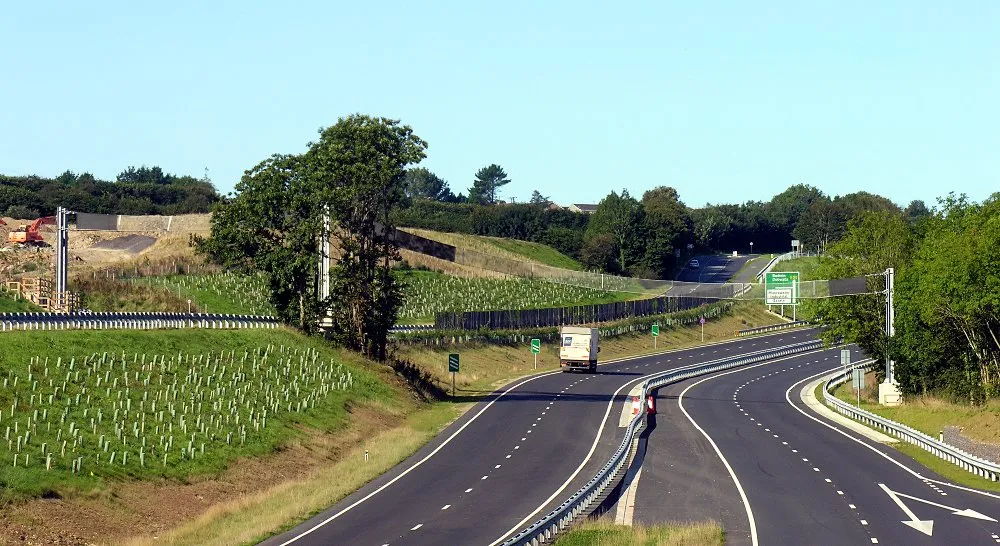
The A38 trunk road ran through the village until the bypass was opened on 19 DecemberRead more
2008. The bypass has two of the most elaborate bat bridges built so far in the UK (previous examples in Wales being wooden posts with cables). Twelve native species of bats are found in the area.
Until 2006, the Dobwalls Adventure Park tourist attraction was located north of the village.
Compare prices across Booking.com, Airbnb, Expedia, and more. Select your dates to see availability.
Pick your must-haves once: provider links open pre-filtered. Each filter lists which sites it applies to.
Compare before you book!
Prices can vary significantly between platforms. We recommend checking at least 2-3 sites to find the best deal for your stay in Dobwalls.
Discover famous landmarks, scenic roads, and more near Dobwalls.
Dobwalls offers many attractions including tourist sites, museums, parks, and local restaurants. Explore famous landmarks, scenic roads, and natural wonders on our interactive map and plan your visit.
Plan your road trip to Dobwalls with Plan Your Road Trips! Add Dobwalls as a destination, and we'll help you find the best route and discover more amazing places along the way.
Dobwalls is located in England, United Kingdom, Europe. The coordinates are 50.4577 latitude, -4.5174 longitude.
Dobwalls has a population of approximately 1,418 people, making it a town in United Kingdom.
Add to your itinerary
Start planning your road trip with Dobwalls as a destination. Create a custom route and discover more amazing places along the way.
Start Road TripDiscover destinations like Tinder
Swipe through stunning destinations near Dobwalls. Save your favourites and add them to your trip.
Essential numbers in United Kingdom
112 also works. NHS non-emergency medical advice: 111. National Highways breakdown assistance on motorways: 0300 123 5000.
Full driving guide for United Kingdom8 notable places within an hour's drive.
waterfall
A series of cascades where the River Fowey drops through ancient oak woodland on the southern edge of Bodmin Moor.
3 km · about 5 min drive
waterfall
A series of cascades through ancient oak woodland on the River Fowey, a National Nature Reserve.
4 km · about 5 min drive
ancient ruins
Three Bronze Age stone circles in a line on Bodmin Moor near Minions, beside the natural stack of the Cheesewring.
8 km · about 15 min drive
landmark
A car-free fishing village of whitewashed cottages packed into a narrow ravine on Cornwall's south coast.
14 km · about 25 min drive
scenic viewpoint
The highest point in Cornwall at 420 m, a long granite-topped ridge in the middle of Bodmin Moor.
16 km · about 30 min drive
landmark
Spectacular complex of enormous biome domes nestled in a former clay pit, housing the world's largest indoor rainforest.
19 km · about 20 min drive
scenic viewpoint
A conical headland on Cornwall's south-east tip crowned by a 14th-century chapel, with views across Plymouth Sound.
26 km · about 30 min drive
waterfall
A mystical 60-foot waterfall that bores through a holed rock in a fern-draped wooded glen near Tintagel.
27 km · about 30 min drive
April to October
Other places to explore near Dobwalls.
Create your perfect itinerary with our calendar-based planner. Add stops, discover attractions along the way, and share your trip with friends.
Start Planning