

film location
Bourne Wood, Surrey (Gladiator opening battle)
The Forestry England woodland near Farnham is where Gladiator's Germania battle was shot, and later Robin Hood, Thor and the Harry Potter finale.
13 km · about 25 min drive
England, United Kingdom · Europe
Deepcut works well as a base: 10 minutes from Camberley, 17km from Brooklands.
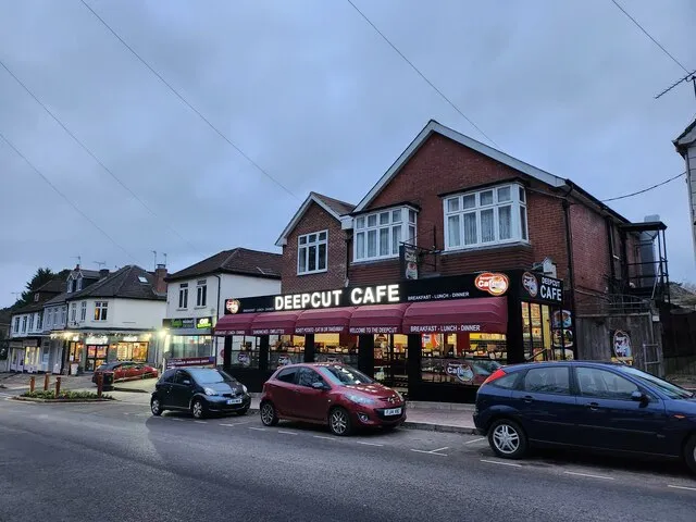
Deepcut is a town located in England, United Kingdom. With a population of 2,477, it is an important destination in Europe.
On a road trip, Deepcut sits in United Kingdom, where you drive on the left. It's in the Europe/London time zone. Below you'll find where to stay, things to do nearby, and everything you need to add Deepcut to your route.
Deepcut is a village in the borough of Surrey Heath in Surrey, England, approximately 28 mi (45 km) southwest of central London. The nearest towns are Camberley, Surrey (3 mi (4.8 km) to the north) and Farnborough, Hampshire (3 mi (4.8 km) to the west). Deepcut is named after the excavations required for the buildingRead more
of the Basingstoke Canal during the 1790s, although the village dates primarily from the early 20th century.
Deepcut was the location of the Princess Royal Barracks and its predecessors from 1906 until the barracks was decommissioned after closure was announced in 2013.
The nearest railway stations are Frimley on the line between Ascot and Aldershot, Farnborough North on the North Downs Line and Farnborough (Main) on the South West Main Line.
Compare prices across Booking.com, Airbnb, Expedia, and more. Select your dates to see availability.
Pick your must-haves once: provider links open pre-filtered. Each filter lists which sites it applies to.
Compare before you book!
Prices can vary significantly between platforms. We recommend checking at least 2-3 sites to find the best deal for your stay in Deepcut.
Discover famous landmarks, scenic roads, and more near Deepcut.
Deepcut offers many attractions including tourist sites, museums, parks, and local restaurants. Explore famous landmarks, scenic roads, and natural wonders on our interactive map and plan your visit.
Plan your road trip to Deepcut with Plan Your Road Trips! Add Deepcut as a destination, and we'll help you find the best route and discover more amazing places along the way.
Deepcut is located in England, United Kingdom, Europe. The coordinates are 51.3051 latitude, -0.7102 longitude.
Deepcut has a population of approximately 2,477 people, making it a town in United Kingdom.
Add to your itinerary
Start planning your road trip with Deepcut as a destination. Create a custom route and discover more amazing places along the way.
Start Road TripDiscover destinations like Tinder
Swipe through stunning destinations near Deepcut. Save your favourites and add them to your trip.
Essential numbers in United Kingdom
112 also works. NHS non-emergency medical advice: 111. National Highways breakdown assistance on motorways: 0300 123 5000.
Full driving guide for United Kingdom8 notable places within an hour's drive.
film location
The Forestry England woodland near Farnham is where Gladiator's Germania battle was shot, and later Robin Hood, Thor and the Harry Potter finale.
13 km · about 25 min drive
film location
The lakeside and woods of Windsor Great Park doubled for the Forbidden Forest and the Hogwarts grounds in Prisoner of Azkaban and Goblet of Fire.
14 km · about 25 min drive
racetrack
The world's first purpose-built motor racing circuit, opened 1907, where surviving sections of the towering concrete Members' Banking rear up out of the Surrey woodland. The museum holds racing cars and aircraft on the original site.
17 km · about 20 min drive
film location
The Skyfall Lodge exterior was built and burned on this MoD heath in Surrey; the location is walkable, though only the ground remains.
17 km · about 20 min drive
museum
The birthplace of British motorsport and aviation, featuring the world's first purpose-built motor racing circuit from 1907.
18 km · about 20 min drive
landmark
Family-friendly theme park near London with LEGO-themed rides, building workshops, and Miniland models.
18 km · about 20 min drive
landmark
Thrill-focused theme park near London catering to older children and adults with intense roller coasters.
18 km · about 20 min drive
landmark
The oldest and largest occupied castle in the world, serving as a royal residence for over 900 years.
21 km · about 25 min drive
4 named roads, passes and coastal drives within 100km.
April to October
Other places to explore near Deepcut.
Create your perfect itinerary with our calendar-based planner. Add stops, discover attractions along the way, and share your trip with friends.
Start Planning