
racetrack
Thruxton Circuit
The fastest circuit in the UK, a former airfield in Hampshire with high-speed sweeping corners that test car and driver to the limit.
7 km · about 15 min drive
England, United Kingdom · Europe
Anna Valley works well as a base: 20 minutes from Ludgershall, 24km from Old Sarum.
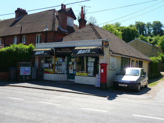
Anna Valley is a town located in England, United Kingdom. With a population of 2,893, it is an important destination in Europe.
On a road trip, Anna Valley sits in United Kingdom, where you drive on the left. It's in the Europe/London time zone. Below you'll find where to stay, things to do nearby, and everything you need to add Anna Valley to your route.
Anna Valley is part of the village and parish of Upper Clatford, Hampshire, United Kingdom. The settlement is located approximately 1.0 mile (1.6 km) south-west of the market town of Andover.
The name 'Anna' derives from the Celtic river 'Anne' meaning 'Ash tree stream' now known as Pillhill Brook on the OrdnanceRead more
Survey Landranger map, though it is still known as the River Ann to older local people.
Tasker Waterloo Ironworks (Taskers of Andover) opened here in 1815 and survived as a manufacturing industry until final closure in 1984. The site is now a modern housing development though there are still signs of Tasker's influence in the village in the form of workmen's houses, a line of terraced houses built for the workers and the former Tasker's hall which is now private housing.
Originally much of the land occupied by the later foundry at the far end of the village was marsh land, known as Clatford Marsh. Robert Tasker noted the fact that the village had quarrying rights to chalk in the nearby hillside. By exploiting this right and quarrying an acre of chalk from the hillside it enabled the marshland to be filled with the quarried materials to act as foundations for the new Iron Foundry situated alongside the PillHill brook which would serve as a source of water power for the foundry. This chalk quarry is still very much in evidence (it is owned by the Parish Council) and can be seen from the road and a footpath that passes along the hillside behind the village leading to the Iron Age hillfort of Bury Hill.
On 20 November 1830 a mob of rioters came from Andover town, they smashed a bridge in Upper Clatford that carried the road over the river Anton and proceeded to vandalise and damage fixtures and equipment at the foundry. A number of arrests were made by a detachment of local Yeomanry and the Duke of Wellington Sir Arthur Wellesley sat on the board of assizes held at Winchester jail when the ringleaders were sentenced to be hanged and a number to be transported to Australia for their crimes.
In 1843 Tasker Ironworks installed a new cast iron bridge in Upper Clatford that exists today, carrying the road over the river Anton towards Church Lane. A later iron foot bridge was installed in Andover in 1851 to carry Ladies Walk over the new Micheldever Road that was cut through the chalk hillside.
The village once had 2 public houses, one situated at the bottom of Sam Whites hill, on the road to Upper Clatford, the hill so being named for a former landlord of the pub. A second public house stood almost opposite Tasker Ironworks.
On Wednesday July 13, 1910 the British Army airship Beta was flying over Andover when the crankshaft broke. The airship landed at Little Park Farm and was later towed by Royal Engineers to the chalk pit opposite the Taskers of Andover Waterloo Ironworks. A new engine was brought from Farnborough, Hampshire and repairs assisted by the Ironworks factory. Beta remained in the chalk pit all night and most of the following day. Crowds gathered to witness this novel sight.
Compare prices across Booking.com, Airbnb, Expedia, and more. Select your dates to see availability.
Pick your must-haves once: provider links open pre-filtered. Each filter lists which sites it applies to.
Compare before you book!
Prices can vary significantly between platforms. We recommend checking at least 2-3 sites to find the best deal for your stay in Anna Valley.
Discover famous landmarks, scenic roads, and more near Anna Valley.
Anna Valley offers many attractions including tourist sites, museums, parks, and local restaurants. Explore famous landmarks, scenic roads, and natural wonders on our interactive map and plan your visit.
Plan your road trip to Anna Valley with Plan Your Road Trips! Add Anna Valley as a destination, and we'll help you find the best route and discover more amazing places along the way.
Anna Valley is located in England, United Kingdom, Europe. The coordinates are 51.1932 latitude, -1.5072 longitude.
Anna Valley has a population of approximately 2,893 people, making it a town in United Kingdom.
Add to your itinerary
Start planning your road trip with Anna Valley as a destination. Create a custom route and discover more amazing places along the way.
Start Road TripDiscover destinations like Tinder
Swipe through stunning destinations near Anna Valley. Save your favourites and add them to your trip.
Essential numbers in United Kingdom
112 also works. NHS non-emergency medical advice: 111. National Highways breakdown assistance on motorways: 0300 123 5000.
Full driving guide for United Kingdom8 notable places within an hour's drive.
racetrack
The fastest circuit in the UK, a former airfield in Hampshire with high-speed sweeping corners that test car and driver to the limit.
7 km · about 15 min drive
film location
The Jacobethan country house in Hampshire that is Downton Abbey itself; the estate opens to visitors for parts of the year.
18 km · about 20 min drive
landmark
Mysterious prehistoric stone circle dating back 5,000 years on Salisbury Plain in Wiltshire.
22 km · about 25 min drive
ancient ruins
The vast earthwork ramparts of the original Salisbury, an Iron Age hillfort later holding a Norman castle and first cathedral.
24 km · about 25 min drive
cathedral
Masterpiece of Early English Gothic architecture boasting Britain's tallest spire at 123 metres and housing the finest surviving Magna Carta.
25 km · about 30 min drive
ancient ruins
A Neolithic chambered tomb near Avebury, over 100 m long and open to walk inside its stone burial chambers.
34 km · about 40 min drive
cafe
A beloved biker cafe on the A32 in Hampshire that draws motorcyclists from across southern England with its welcoming atmosphere and hearty food.
35 km · about 40 min drive
cafe
The Hampshire outpost near the South Downs, 45 minutes from Goodwood and close to the National Motor Museum at Beaulieu.
35 km · about 40 min drive
5 named roads, passes and coastal drives within 100km.
April to October
Other places to explore near Anna Valley.
Create your perfect itinerary with our calendar-based planner. Add stops, discover attractions along the way, and share your trip with friends.
Start Planning